pwbriggs's Comments
| Changeset | When | Comment |
|---|---|---|
| 178204245 | Okay. I think there are additional tags that could be added to better represent this, but I'm not familiar enough to be sure. I think this should be good enough for now. Thanks for your help! |
|
| 178204245 | But this is still designated 223rd Ave, and is not considered a driveway? Is there a sign at the entrance to the private section that says "private road" or "keep out"? Thanks |
|
| 178383795 | Thanks for the edit @sd97. In addition to the note above from @Glassman, I'd like to point out that Google Maps' licensing prohibits use in OpenStreetMap: please make sure you don't add any data derived from Google Maps or other proprietary sources. Thanks! |
|
| 178563724 | Thanks for these 5/405 interchange edits. I *think* they're good but I haven't looked into the tagging super closely, nor am I very familiar with the interchange lanes. But broadly these changes look good, so... thanks! If you want a more detailed / expert review, you could probably ask for help on https://slack.openstreetmap.us/ -- I've found that it's a great resource for consulting with other contributors. |
|
| 178204245 | Thanks for the contributions, and welcome to OpenStreetMap! Could you confirm whether this is a continuation of the public 223rd Ave, or whether this is a private driveway? Thanks! |
|
| 178106148 | Thanks. Just out of curiosity, could you link me to the Sound Transit document you referenced, or otherwise explain how to access it? |
|
| 178752686 | Thanks! Building data is definitely sparse in this area, so thanks for helping out! |
|
| 178737812 | Thanks for the contribution! I expanded the direction from NW to Northwest (that's the convention in OpenStreetMap), but otherwise your changes look good. Thanks again, and welcome to OpenStreetMap! If you have any questions, please feel free to reach out here, via user messages, or on Slack at https://slack.openstreetmap.us/ |
|
| 177876480 | No problem, thanks for your work. Happy mapping! |
|
| 177323719 | Hey, I noticed you added a tag "ref:"="id3king=248". Did you mean "ref:id3king"="248"? Seems like the tag name was split accidentally. There are a few more of these that I found on https://taginfo.openstreetmap.org/keys/ref: so if you know what these tags are, do you mind fixing those? Also it would be nice to have a documentation page on the wiki. I've never heard of id3king, is it some data source? |
|
| 177915190 | Thanks for the edits. Here's a non-exhaustive review of some things I see. * Looks like you have bus:lanes:backward=designated|yes in some places where I think it's bus:lanes:backward=yes|designated. *:lanes:backward=* tags are tabulated from the perspective of traveling in the backwards direction on that road. So if a road has 2 lanes per direction and the curb lanes are both bus lanes, it would be bus:lanes:*=yes|designated for both. * I think this should have access:lanes=* as well. That's the "only" in "Bus Only". So in addition to bus:lanes:backward=yes|designated I think there should be access:lanes:backward=yes|no to indicate that general traffic isn't allowed in that lane. Or maybe it's implied, but I'm not sure. * is bicycle=designated really the case for both directions in places where e.g. cycleway:left=no? * Sometimes when approaching an intersection, the bus lane changes to a right turn lane. Not sure if there's any of these south of MLK, but I've represented those as turn:lanes:forward=|right with turn:bus:lanes:forward=| and turn:bicycle:lanes:forward=| based on the signs which read something like "Right turn only, except buses and bicycles". Yeah, I enjoy lane tagging, but it can be super tedious sometimes. Thanks for working on this! iD is kind of a pain for doing lane tagging, in my experience. Maybe this is an opportunity to try out JOSM ;) https://josm.openstreetmap.de/wiki/Styles/Lane_and_Road_Attributes has some quirks but it's the best visualizer I've found. Well, thanks! Let me know if you have any questions. I think iD suggests it in the sidebar after submitting a changeset, but if you're not on the OSM US Slack (hard to say from a basic search), I've found that to be a super helpful place to ask questions and discuss (especially #tagging channel): https://slack.openstreetmap.us/ Happy mapping! |
|
| 177978217 | Hey, thanks for the contribution! I notice that you added this as a Flock gunshot detector. However, in your note note/5151135, you said that this was a camera. Which is it? Thanks again, and welcome to OpenStreetMap! |
|
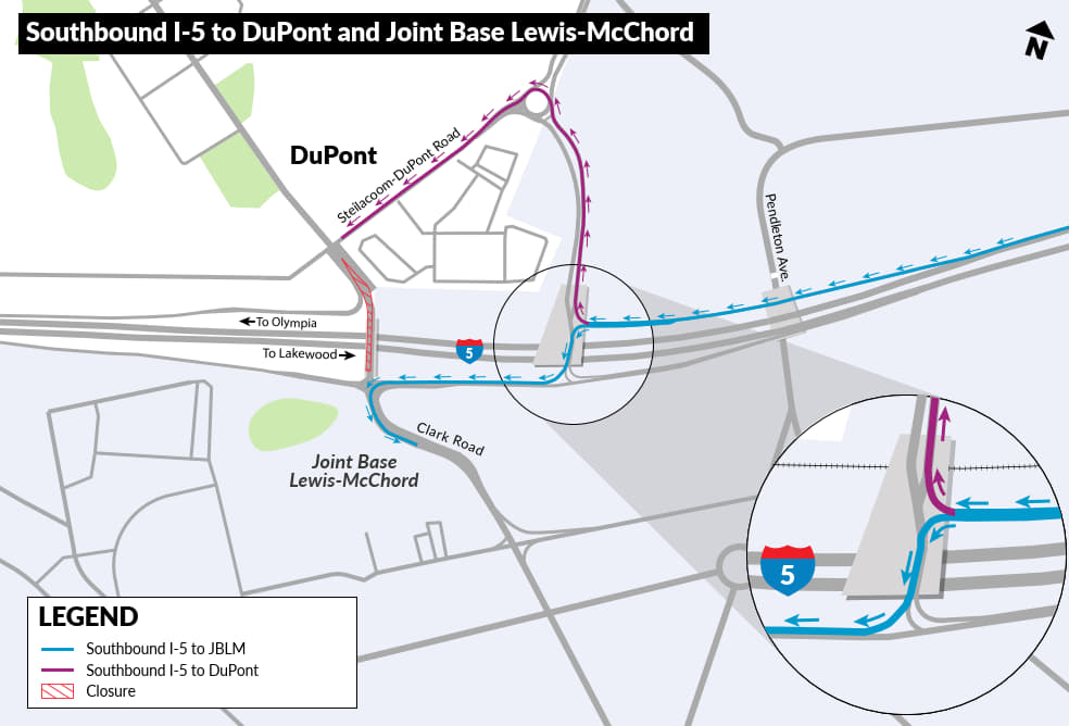
| 177876480 | I think this is in fact 2-way, could you provide documentation that this is currently one-way? According to the WSDOT project page (https://wsdot.wa.gov/construction-planning/search-projects/i-5-mounts-rd-steilacoom-dupont-rd-corridor-improvements), the I-5 SB exit 119 is now open and traffic heading to Lewis McChord Base (via Clark Rd) travels west on this segment to get to clark. see exit 119 diagram at https://s3-us-west-1.amazonaws.com/ehq-production-us-california/b022b1d2f16449c50f8423b25b491f4c1024bc71/original/1763405817/19cd4c9ec1fbfb2300780bb82d381f71_MountsRoad-map-Stage4SouthboundTraffic.jpg I'm changing this back to two-way, and will look into changing the road classification. But please let me know if you have recent on-the-ground info or current data about this. |
|
| 163311933 | Filing obligatory feedback complaint that you added a duplicate building: way/1365202834 Thanks for your work on this, happy mapping! |
|
| 177825520 | Looks good, thanks for the contribution! Address data is pretty sparse in this area, so feel free to add addresses as needed. I'll look into pulling some data from any publicly-licensed county address data to see if I can get some of these in bulk. Thanks again, and welcome to OpenStreetMap! |
|
| 176835267 | Fair. I believe I had tagged it that way because the flats are still "under construction". But I think it's close enough to completion that this is okay. |
|
| 177318280 | Thanks. The extra node ("point") is redundant—the tags on the way ("area") take care of that. See osm.wiki/One_feature,_one_OSM_element for more info. Thanks again for the contributions, and happy mapping! |
|
| 177594700 | Thanks. Is there any particular reason you used multipolygon relations instead of just a normal way-area? E.g. relation/20128685 If you don't know what that means, then it's just because the iD editor can be a little annoying about creating extra relations. Otherwise, I'd be interested to hear your reasoning. |
|
| 177665729 | Very unlikely that there's a camera at the center of this intersection, though I do see some cameras on a streetlight on the south side of this intersection. They look like normal city traffic or surveillance cameras though, I don't recognize them as Flock. Please don't tag cameras as manufactured by Flock unless you're sure. I'm removing this camera for now, let me know if you have more details about which camera you're intending to map and I can correct the location and information. |
|
| 177665818 | A camera wouldn't be placed at the very center of the intersection (and it seems extremely unlikely that there would be a camera manufactured by Flock Safety in this area). Are you referring to the nearby emergency phone and camera (node/11924024811)? Or just a regular City of Seattle traffic camera? Please provide more details so we can get this added accurately. |