dieterdreist's Comments
| Changeset | When | Comment |
|---|---|---|
| 57314575 | maybe this is an iD issue. You are the second person in short time who adds a park tag to the tree covered areas of Villa Borghese. Please take care when modifying the existing map, there is already an object for the park, which has the park perimeter, your edit on the tree perimeter doesn't make sense. |
|
| 56831490 | Hi, I just found this edit and wonder whether this is a documented bot? Are you aware of the automated edits code of conduct and following the provisions?
|
|
| 18106409 | Hello Bryce, there is an issue with the wetap namespace tags. Tags like wetap:status and object level source tags and wetap:photo should rather be standard tags (to avoid tag fragmentation). The edits I have seen so far are rather old, do you still use these tags? |
|
| 17421622 | Hello Bryce, there is an issue with the wetap namespace tags. Tags like wetap:status and object level source tags and wetap:photo should rather be standard tags (to avoid tag fragmentation). The edits I have seen so far are rather old, do you still use these tags? |
|
| 18106498 | Hello Bryce, there is an issue with the wetap namespace tags. Tags like wetap:status and object level source tags and wetap:photo should rather be standard tags (to avoid tag fragmentation). The edits I have seen so far are rather old, do you still use these tags? |
|
| 16610678 | Hello Bryce, there is an issue with the wetap namespace tags. Tags like wetap:status and object level source tags and wetap:photo should rather be standard tags (to avoid tag fragmentation). The edits I have seen so far are rather old, do you still use these tags? |
|
| 17146816 | Hello Bryce, there is an issue with the wetap namespace tags. Tags like wetap:status and object level source tags and wetap:photo should rather be standard tags (to avoid tag fragmentation). The edits I have seen so far are rather old, do you still used these tags? |
|
| 41246186 | Io non capisco com'è successo che Polline Martignano è diventato il Quartiere Ostiense in questo changeset.
|
|
| 25650351 | "Everybody will reasonably understand it is likely part of the complex's ownership, even if not included with the specific building tagging, so I don't think this is an issue at all." --> I was arguing that "Palazzo Braschi" probably includes the courtyard, but in building=* it shouldn't be included. Of course we could put only the name on the outline, but then it wouldn't be clear to what it refers. Anyway, this is nothing particularly relevant for this changeset and we should better speak somewhere else about it. As I had written: sorry for the noise. |
|
| 25650351 | OK, sorry, maybe I was too fast. I agree the tagging on the way in question (Palazzo Braschi) was somehow questionable as well. On the one hand, the inner yard can arguably be seen as part of the palazzo, also of the name "Palazzo Braschi", but on the other hand, this inner part isn't building=yes. |
|
| 25650351 | this seems to be an undocumented semiautomated edit. Moves tags from the outlines of the features to the multipolygon, i.e. it removes the properties from the "holes". Please undo this. There is a difference between tags on a way and tags on a multipolygon relation, in case the relation has holes.
|
|
| 48070346 | there are some problems with this edit.
|
|
| 33094194 | This "correction" deleted a quite complex way that described a tree covered area: 201393173 |
|
| 56552650 | Hello Davide, welcome to OpenStreetMap and thank you for editing. It looks as if something went wrong with your edit, there are mainly deletions of long standing objects, mostly already edited by several users. In these cases, usually, even if you want to make bigger changes, you should try to preserve the history and change those objects that are already there, rather than deleting them. It might also make sense to write an message to the former editors or even better, to the talk-it-lazio mailing list. If you can explain what you wanted to achieve I can try to help you. Actually both of you are right, because these should only be trees (by the shape they describe, and how they were originally tagged), but after an edit some months ago, there is also a park tag (which I will fix now). Still there is no reason to delete these objects, as long as they represent what is there on the ground.
|
|
| 56307924 | sehr gut, das ist schon mal ein Riesenfortschritt, vielen Dank. Den Gehweg würde ich allerdings auch noch bei den Verkehrsflächen sehen. |
|
| 41148041 | per me non c’è bisogno del way con i tags, ma ci potrebbe anche essere, l’importante è la consistenza a livello di dati: non ci devono essere micro-regioni Italiani (boundary=administrative e admin_level=4) con nomi come “Scoglio di Punta del Duce”, perché lo scoglio non è una entità amministrativa |
|
| 41148041 | this changeset has introduced a lot of errors, because it added tags to islands, thereby defining them administrative level 4 entities (boundary=administrative, admin_level=4), a level that is called "regione" in Italy.
|
|
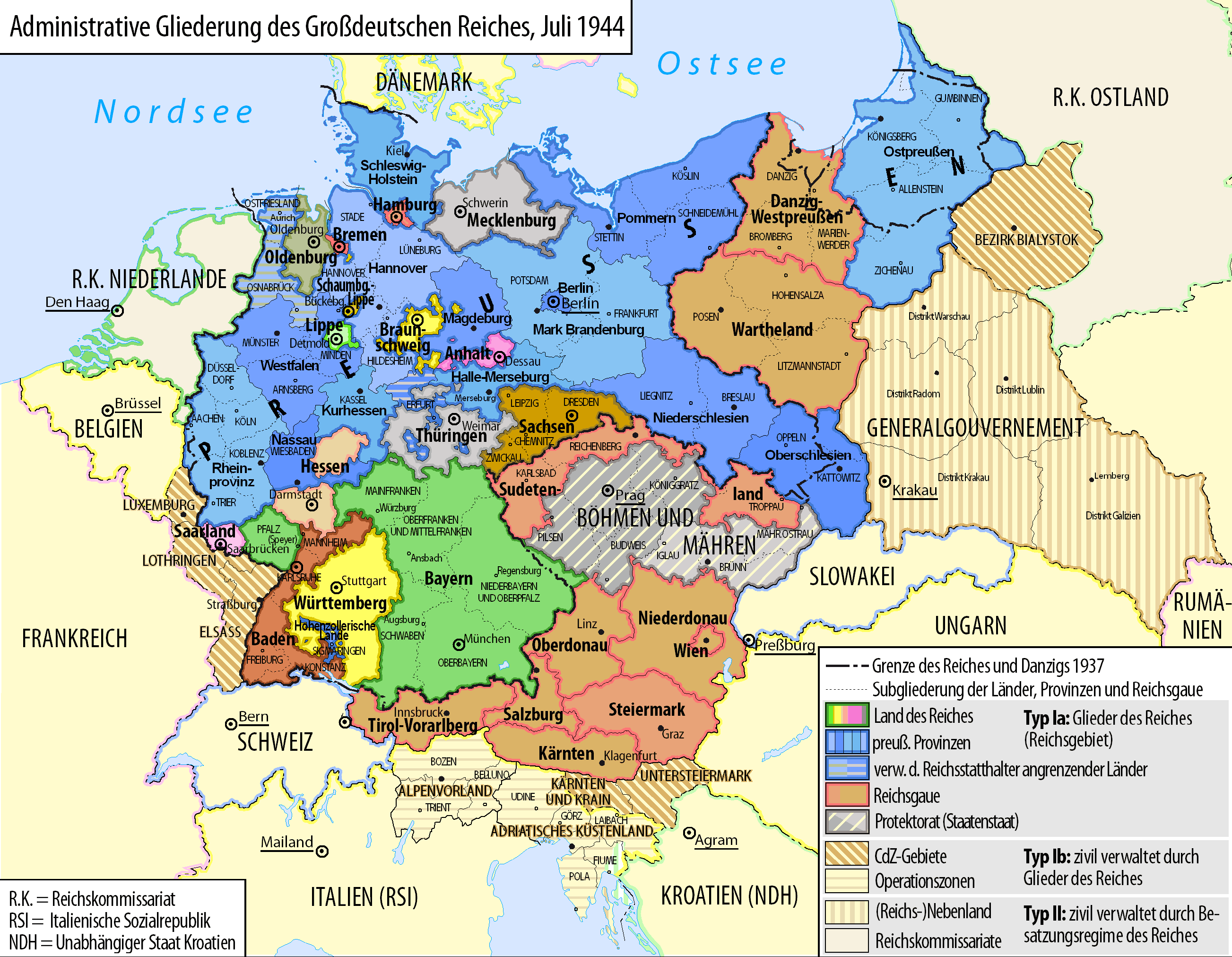
| 55669953 | Polemisch gefragt, könnte man doch, wenn man gerne das Königreich Württemberg im OSM von 2018 haben will, z.B. auch diese Grenzen mappen, die damalige Situation hat auch noch Auswirkungen bis heute: https://upload.wikimedia.org/wikipedia/commons/7/7a/Grossdeutsches_Reich_Staatliche_Administration_1944.png
|
|
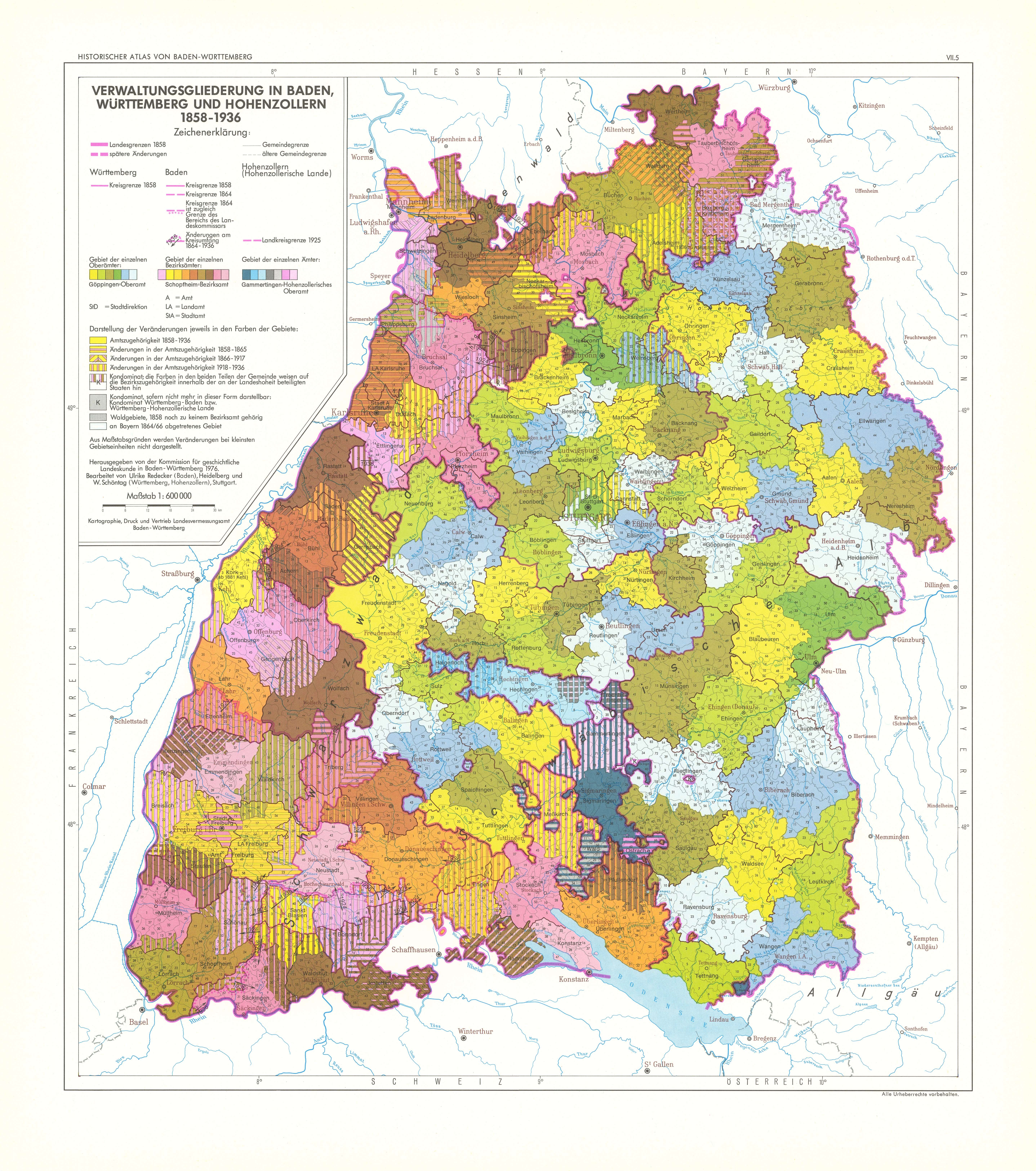
| 55669953 | in Baden sieht es übrigens ähnlich aus, auch da gibt es nicht einen festen Zustand über hundert Jahre, sondern Veränderungen: z.B. https://www.leo-bw.de/media/kgl_atlas/current/delivered/bilder/HABW_07_05.jpg |
|
| 55669953 | Leider sind es nunmal die tags, die ein Objekt beschreiben. Die Württemberg relation hatte vor dem Löschen diese tags, die in der Kombination grundsätzlich nicht richtig waren:
m.E. schonmal falsch, das ist kein "alternativer Name" für das Königreich Württemberg mit start_date 1806, sondern ein anderes Objekt (Nachfolger). boundary historic soweit OK, wobei historische, d.h. nicht mehr existierende Gebietskörperschaften nicht eingetragen werden (nicht verifizierbar vor Ort, alten Karten kann man diesbezüglich nicht trauen, nicht aktuell existent). end_date 1945 falsch für das Königreich Württemberg (1918) name Württemberg
Wenn man sich das Gebiet ansieht, dann ist auch start_date=1806 falsch, weil manche Teile erst 1809 und 1810 dazugekommen sind
D.h. dieses Objekt hat es zu keinem Zeitpunkt so gegeben, wie es durch die Kombination der tags beschrieben wird, vielmehr war das Objekt eine eklektizistische Mischung verschiedener historischer Zustände in einem. |