osminng's Comments
| Changeset | When | Comment |
|---|---|---|
| 154047731 | It is an interesting question this way, how the "dictionary-like" usage of Wikipedia and Wikidata counts, what sus242424 pointed out. Aka. checking the further name variants of already mapped features of OSM, one-by-one manually, not by any importing mechanism. Sensum stricto, mcliquid is right, Wikipedia shall not be used in any cases as a source, according to the red box. No further question then. But sus242424's comment also worth the consideration. As these features are already there in OSM, there is no geodata import in these cases. But rather information cross-check, according to mostly already linked Wikidata and Wikipedia pages, where only a foreign naming standard is checked. |
|
| 154047731 | Hello mcliquid, Thank you for the feedback and the clarifications! You are right, the bounding box of changes should be definitely smaller, corresponding to lower administrative units or even individual features in this case. Try to focus more on that in the future! Wikidata as (already linked to each of these nodes) source was unfortunately missed from the source field. But I'll make sure to double-check the sites, you cited. Thanks again!
|
|
| 143415884 | I guess it is clear now. Deleting the original was correct as that line not exists anymore And the ferry from Gibraltar to Tanger-MED (which is a new route?) should be drawn from scratch. |
|
| 143415884 | Hello maiwolf, On the operating company's website I found. That's why I'm a but unsure because they might simply left it in their database. But it can be also true that it was resumed since last October Maybe I try to ask directly from the company |
|
| 143415884 | Hello maiwolf, Could you please confirm (based on field experience) that this ferry line does not exist anymore? I checked on the website and you can still book Gibraltar-Tanger ferries. |
|
| 148897760 | Bonjour Michel, Désolé pour ce problème. J'ai essayé de vérifier les "relations" lorsque le changement de géométrie a été effectué, mais ce petit problème subsistait alors. Merci de l'avoir corrigé ! |
|
| 130262224 | Hey,
|
|
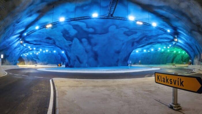
| 130262224 | Hello @DoKimbDeSun I'd just like to ask that what was the reason for putting way/387380584 to layer=-2 instead of -1? I just wonder, because in our OSM-based solution, it caused a bit of a visual glitch. And based on images (no Mapillary unfortunately), we saw no such huge change (https://guidetofaroeislands.fo/wp-content/uploads/2021/06/eysturoyartunnilin-worldrsquo-s-first-under-sea-roundabout-1-700x394.jpg), which calls for this difference, in contrast to all the other layer=-1 of the tunnel system. |