manings's Comments
| Changeset | When | Comment |
|---|---|---|
| 53543866 | hi hpalbuero, we noticed your edits was part of an organized edits, we documented it here: https://github.com/OSMPH/papercut_fix/issues/33 Also using streetview is not allowed in OSM. |
|
| 53308757 | hi hpalbuero, we noticed your edits was part of an organized edits, we documented it here: https://github.com/OSMPH/papercut_fix/issues/33 Also using streetview is not allowed in OSM. |
|
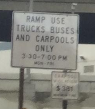
| 53630367 | its the white sign: https://user-images.githubusercontent.com/353700/32947045-064b9c6a-cbc0-11e7-8b62-c8378ccea236.png |
|
| 53630367 | Hi Jan, This the mapillary I used: https://www.mapillary.com/app/?pKey=5c24R-YQaeEW-39S7dOprQ&focus=photo&lat=37.783862&lng=-122.393088&z=17 From the image, it shows only HOV restriction. |
|
| 53209008 | You added a turn restriction on a cycle route. Curious if this is valid: relation/7677436/history Keep on mapping. |
|
| 51502902 | Instead of the name tag, could the fixme be used instead? |
|
| 50068382 | There were duplicated road segments as a result of this revert. Per OSM-US list, this is a compromise to remove the sapm. They are all fixed now: https://github.com/mapbox/mapping/issues/310 |
|
| 49670819 | Thanks for reply. I haven't check the data completely but a quick look seems they are all good. However, I encourage you to upload as often as possbile so that we don't have a changeset that is too big. Thanks for mapping. |
|
| 49670819 | Hi, PanierAvide. This edit spans the whole US. Can you point to a documentation in the wiki about this edits. On quick look this is a mechanical edit and should follow community guidelines: osm.wiki/Automated_Edits_code_of_conduct |
|
| 48449704 | @Streptokilla, welcome to OSM! A couple of issues Im seeing in these edits and the surrounding area: - invalid relation in landuse=forest
Some edits doesn't correspond to what I'm seeing in the imagery. Hope someone local can verify. |
|
| 48270769 | There are a lot on non-existing parks and ponds here. Deleted them. I also commented on your other changes on best practices. changeset/48324007 |
|
| 48270484 | Hi Nikos welcome to OpenStreetMap!
See changes here: changeset/48323804 |
|
| 48203967 | Hi Haystacks. Great! Send me a message if you have Qs! |
|
| 48203967 | Hi Haystacks. Welcome to OpenStreetMap!
Thanks again for contributing and welcome to our mapping community! |
|
| 48202080 | Hi hawkinsry, after looking at several imagery sources, I don't these footways exist on the ground. In addition the zigzagging of the footways doesn't make sense to me. I reverted your edits here: changeset/48216763 |
|
| 48175984 | Hi Martha Leena, thank you for contributing to OpenSTreetMap! I noticed you tagged existing nodes of a building and roads with building=yes. I assume this is a mistake? I reverted/removed your edits in this changeset: changeset/48184953 This maybe because you are new with using JOSM, that's OK. Let's be careful next time, keep on mapping! If you have questions don't hesitate to contact me. |
|
| 48151330 | Thanks for fixing. I fixed a few more here: changeset/48162693 Changes I made were the following: - overlapping buildings
|
|
| 48151330 | Hi Bhojaraj, thank you contributing to OSM! I noticed some of your buiding traces have duplicated nodes/ways. Can you fix them. Since you use JOSM, please use the Validator plugin. |
|
| 48156156 | hi Bhojaraj, Thanks for contributing to OSM! I noticed you created a very large building here, perhaps a mistake? Can you fix it now? |
|
| 47761077 | Footways around this area does not exist on imagery, removed them. |