jptolosa's Comments
| Changeset | When | Comment |
|---|---|---|
| 150149356 | Hola, acá has duplicado la localidad de Junquillar y moviste todo usando una alineación incorrecta nuevamente. |
|
| 150147758 | Hola, la alineación que estás usando es incorrecta. La capa de fotos Bing está especialmente desplazada en este lugar. Es preferible guiarse por Esri.
|
|
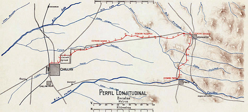
| 149530939 | Hola, según se ve en un mapa de una de las páginas que citaste, la línea doblaba hacia el sur casi hasta entrar a Pinto, del mismo modo que el artículo de Wikipedia habla de una estación con ese nombre: http://www.ferrocarrilesenelconosur.co.uk/Resources/Chillan%20map%20small.jpg |
|
| 149454938 | Hola.
|
|
| 147937150 | Hola, que un "patio de juegos" posea un par de árboles o pequeño jardín no lo convierte en parque. Para que sea parque su función principal debe ser la de proporcionar un área verde de esparcimiento. |
|
| 74651141 | Hello, the tag "Km=9" means the same as addr:milestone=9. I guess should be changed all of them. |
|
| 104084464 | Hello, thanks for advice, I have fixed it. |
|
| 147237721 | El polígono farmland debe excluir a los edificios, para los cuales se utiliza farmyard.
|
|
| 147178500 | Un polígono landuse=farmyard sólo se debe usar para agrupar los edificios. No se debe incluir las tierras de cultivo o de pastoreo en este.
|
|
| 147236449 | Hola, intermittent=no es un valor por defecto. No se debe utilizar a menos que dé lugar a creer lo contrario. |
|
| 146137145 | If there are no other customers is not a reason to use service=spur. In this case the tag to denote that you say is usage=industrial. By definition a service=spur only supply the function of access to a company, in this case for track from Nueva Aldea village to Planta Nueva Aldea. |
|
| 146137145 | service=spur is only applicable to short tracks accessing to a company, not to a entire branch. |
|
| 146906024 | Hello, you have retagged some railways from railway=abandoned to railway=disused where the tracks have clearly dismantled according satellite imagery. |
|
| 144979247 | In the changesets 144564187 and 144809115 also some polygons was broken. Probably in more changesets too. |
|
| 144979247 | Hello, In this changeset you have damaged polygons of some lakes causing its disappearance. Please be more careful and do smaller changesets for a better checking. Regards.
|
|
| 144269805 | Hello,
|
|
| 144044825 | Hello Tomáš, thanks for your response. The usage of a second water polygon with intermittent=yes seems to be a practice only in some places, not a rule. In Chile generally we use one polygon matches with full level when a reservoir is usually filled during at least a moment in the year. The case of "Lagunas de Teno" is different. The level that you saw is the same during all of the year and the same during more than a decade. Then the solution used by us is mapping the new level without intermittent polygon. Further, "Lagunas de Teno" is originally a natural lake with a dam building later to elevate its natural level. In these case the common practice is use water=lake instead water=reservoir, but is debatable. Some other lakes in the same situation are "Laguna del Maule" and "Laguna del Laja". Regards. |
|
| 142683682 | Hello csimeona22. Also various objects like emergency phones or traffic signs was not moved together with streets. Considering all the best solution was returned to the original position of all these objects.
|
|
| 142838817 | Hubo un malentendido la vez anterior, sólo se llama Coronel desde el lado de La Granja. Por el lado de La Florida y de La Pintana (hacia el sur de Santo Tomás) se llama Bahía Catalina.
|
|
| 142125612 | Hola, si sólo puedes entrar a la Granja Aromática con reserva creo que private es el más adecuado (similar a entrar a un condominio) y además por necesidad debe quedar como private todas las vías que se ramifican de una calle marcada como private. Eliminé un dam que estaba duplicado y ocupando el lugar del bridge=yes. Pero habría que ver si realmente es un puente o si es parte del dique como ocurre en Rapel. |