Udarian's Comments
| Changeset | When | Comment |
|---|---|---|
| 178615598 | next time when adding a business please add more then a name, for a POI to be useful it needs a tag like shop=* or amenity=* to describe what the object is. also when adding address data please add at least addr:street=* because that one is harder to correctly interpolate. Happy mapping,
|
|
| 178607504 | there was a small issue with this changeset, when you attached node node/544218590 to the new bridge area it shifted if significantly from the centerline and thus correct alignment for the motorway link ways it is a part of. This has been fixed. Please be more careful next time. Happy mapping,
|
|
| 178483112 | this changeset added names to two separate roads that do not seem to be connected and yet they both have the same name, can you please check which one is the Northwest 21st and which isn't and fix the one that isn't. Happy Mapping,
|
|
| 178483014 | the comment on this changeset does not properly describe what was done in this changeset, looking at it in OSMCha this seems to more of a renaming of a business rather then a driveway fix. next time please try and leave a better changeset comment. osm.wiki/Good_changeset_comments Happy mapping,
|
|
| 178467425 | the way added in this changeset seems to be a duplicate (without any useful tags on it) and the relation seems have no tags and no roles, why did you do this, what was your intention with this changeset. Happy Mapping,
|
|
| 178405555 | this changeset does not have a comment, comments are important for various reasons. Next time please leave a changeset comment describing what you did. for more info see osm.wiki/Good_changeset_comments Happy mapping,
|
|
| 178377969 | the ALPR added in this changeset is in the middle of the road so I doubt the accuracy of its position. Can you please check its position and fix it. Happy mapping,
|
|
| 178372075 | are you sure that this is hgv=no because this service road is part of a commercial area that has warehouses (where the service road leads directly to the warehouses) so I would expect that hgv vehicles could use the service road. Happy mapping,
|
|
| 178350756 | can you please double check whether or not the maxweight applies to the non bridge sections of road like way way/1368282776 Happy Mapping,
|
|
| 178366875 | also, looking at various aerial imagery I have doubts about the alignment of way way/1476223639 |
|
| 174648596 | please respond |
|
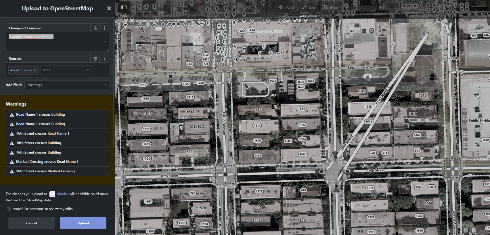
| 178326125 | This changeset has a dragged node in it, I have fixed the dragged node. The dragged node was node node/9744499948 because it was moved north, and as it is connected to several ways (roads and footways), the shape (alignment) of those features also got changed, this lead to data issues as the shape was incorrect. This is a common and easy mistake to make so don't sweat it, but next time please try to avoid such issues. An easy way to do so in iD (the OSM editor that pops up when you click edit on the main OSM website) is to look out for error's that iD outputs. The wording for some of the common errors iD outputs when you have a dragged node is usually worded along the lines of "Road Name 1 crosses Sidewalk" or "Road Name 1 crosses Road Name 2". When these pop up in iD there will usually be UI elements in the issue box with common fixes, for dragged nodes you would ideally move the node back to its old location either by undoing to before the change that caused the issue or moving it manually. Usually any issues that exist on a feature in the changes you want to upload to OSM will pop up in a list in the uploading UI, you can click on these and it will take you to them so you can see if you can fix them. I have attached an example image below of what the upload UI may look like when these issues pop up from a dragged node https://raw.githubusercontent.com/Udarthegreat/public-sources/refs/heads/main/other/Screenshot%202026-02-09%20144645.png . Happy Mapping,
|
|
| 178159584 | I was using custom imagery, but Bing aerial should be good enough in the area. |
|
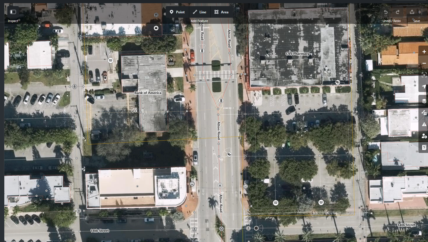
| 178159584 | The following screenshot is of iD using the latest imagery I know of in the area: https://raw.githubusercontent.com/Udarthegreat/public-sources/refs/heads/main/other/Screenshot%202026-02-05%20182343.png
Happy Mapping,
|
|
| 178159584 | the position on this ALPR seems incorrect as it is in the middle of a road (in a lane) on several aerial imagery, it is also some ways away from the nearest traffic light so I can't say with certainty that it is attached to that. Please double check the position of this ALPR. Happy Mapping,
|
|
| 178119750 | I have asked you this before, please when you add a feature don't just add a name and a housenumber, at minimum add the type of business (amenity=* etc) and the street name of the address if you are going to add address info. for OSM POI's to be truly useful they need at least a tag telling what they are. I have tagged it as a gym with sport=boxing, if that is incorrect feel free to fix it, also what street is this POI on as I didn't think I would correctly guess that based of of the provided information. Happy Mapping,
|
|
| 178119266 | some of these changes are incorrect as the imagery used is a bit out of date in the area, it is the latest available in iD but somewhat out of date. There is somewhat newer imagery in the area from the county that can be used in iD using the following custom imagery link: https://imageserverintra.miamidade.gov/arcgis/rest/services/Woolpert2025/ImageServer/exportImage?f=image&bbox={bbox}&bboxSR={wkid}&imageSR={wkid}&size={width},{height}+ There is the fact that the contributor that added several of these construction areas seems to be a local to the area. Happy Mapping,
|
|
| 178113184 | a few notes, first landuse tags usually should not be on the same way as the building tag, aka if you want to add those tags please trace the area the apartment complex actually takes up (the full grounds) next time. Second the surface tag doesn't really apply to an apartment complex like this. Along the same lines, "concrete_block_and_stucco" is not correct as usually materials and surfaces should be individually listed, for example "concrete_block;stucco". For more information on common values for the material tag see https://taginfo.openstreetmap.org/keys/building%3Amaterial#values . Happy Mapping,
|
|
| 178096858 | two issues with this changeset, first and foremost, you created a dragged node, next time, before you upload a changeset please make sure that there aren't any vertexes that have been dragged beyond their alignments, doing so in iD tends to give you errors.
I have gone ahead and fixed both of these issues. Happy Mapping,
|
|
| 177982730 | changeset generated with speedwalk and uploaded from JOSM.
|