Marián Kyral's Comments
| Post | When | Comment |
|---|---|---|
| OSM: Why can't contributors check/correct their own work! | Sorry, it is PoTlaTch… |
|
| OSM: Why can't contributors check/correct their own work! |
Really depends on way, how are you working. But in iD or PoTTlach ;-) you have no checks at all. |
|
| OSM: Why can't contributors check/correct their own work! | I know several advanced mappers that tested JOSM and they don’t like the way, how it works and think that JOSM is user unfriendly. |
|
| OSM: Why can't contributors check/correct their own work! | JOSM has many controls and data validations on “commit”. I’m notified when something seems to be wrong and I can fix it immediately. iD has nothing like this. Using of any external tool that is updated next day, is not much comfortable. You need to not forget and have a time to do it. There are some possibilities: 1) implement basic validations to iD 2) implement basic validations to OSM API 3) implement a special layer on main osm.org page, so any error became visible almost immediate. |
|
| I want create map like this. based on OpenStreetMap? | What about umap? http://umap.openstreetmap.fr Or Leaflet http://leafletjs.com/ |
|
| Long Names of OpenStreetMap | At the other side - we should not do mapping for render. It is not my fault that renders does not render it better. |
|
| FacilMap 2 has been released | Nice. But If I do a long press on church inside park, it give mi details about park and not about the church. |
|
| JOSM and Me... (DeBigC) | I did some edits in iD, but soon switched to JOSM. And this days I’m not able to use iD for anything more than simple quick fixes. |
|
| Č. Těšín, vložení lesního mokřadu | Pěkné, díky ;-) |
|
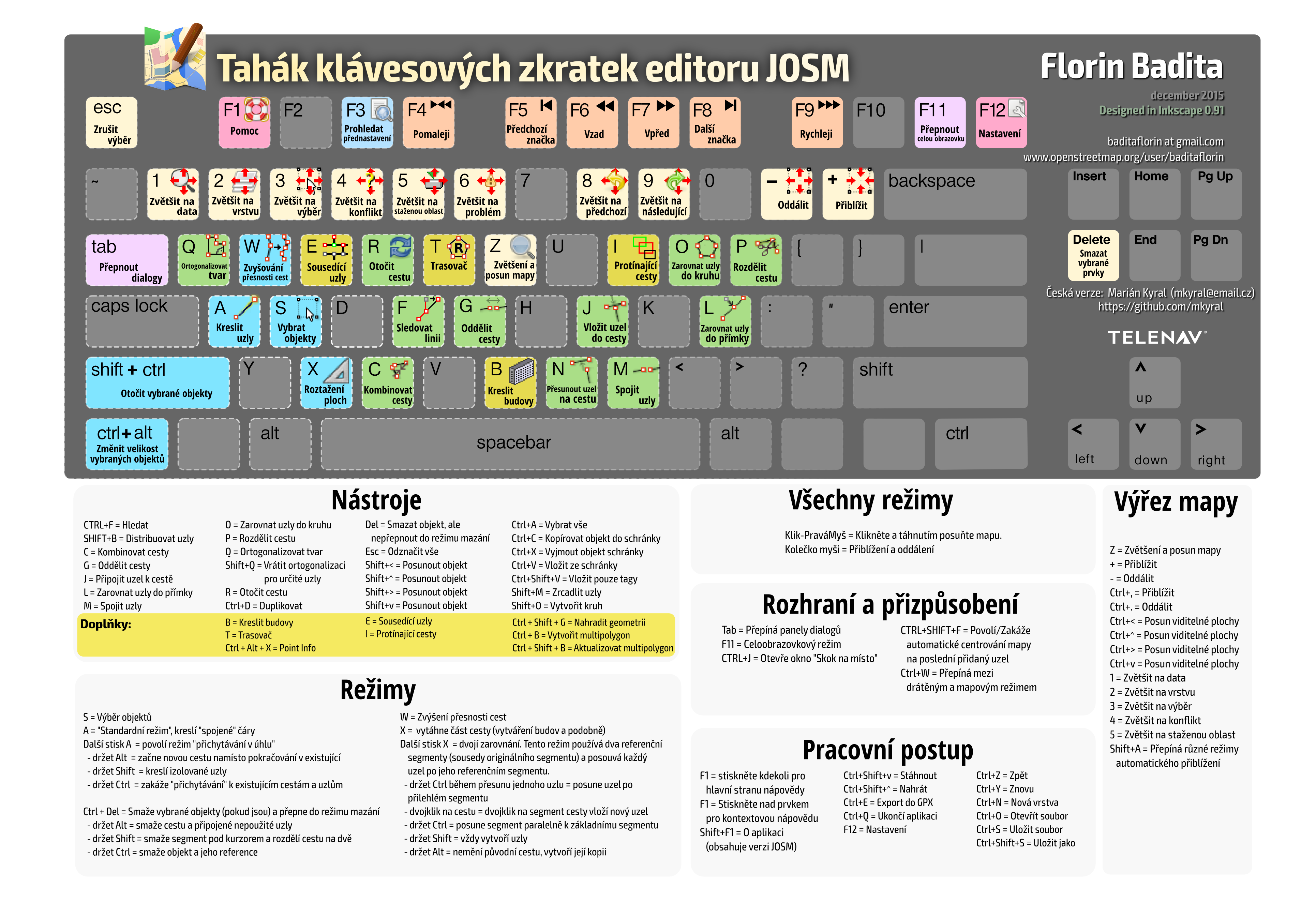
| My christmas gift for the OSM Community - JOSM Keyboard Shortcuts Cheat Sheet 300 DPI | So I’ve made some changes and Czech version is available on my gihub: https://raw.githubusercontent.com/mkyral/osm/master/JOSM_tahak/JOSM_Keyboard_Layout_CZ_final_300dpi.png |
|
| My christmas gift for the OSM Community - JOSM Keyboard Shortcuts Cheat Sheet 300 DPI | Also EXO 2 font looks good: http://ndiscovered.com/exo-condensed-expanded/ |
|
| My christmas gift for the OSM Community - JOSM Keyboard Shortcuts Cheat Sheet 300 DPI | So it seems like Open Sans Condensed and Ubuntu Condensed (little bit sized down) could do this job. |
|
| My christmas gift for the OSM Community - JOSM Keyboard Shortcuts Cheat Sheet 300 DPI | Thanks, but only first font contains Czech characters, but unfortunately is unreadable on small size. Will continue with searching. |
|
| My christmas gift for the OSM Community - JOSM Keyboard Shortcuts Cheat Sheet 300 DPI | Hi, thanks a lot for the gift. I’ve started with translation to Czech. I’m almost done, but found some issues: 1) TW fonts are commercial - any suggestion for free replacement? 2) Ctrl + Delete + hold Alt = Help/Action/Delete#Altmodifier and Ctrl + Delete + hold Ctrl = Help/Action/Delete#Ctrlmodifier This is wrong description in source page. In fact, there is Delete mode and Ctrl, Shift and Alt are modifiers of the mode: https://josm.openstreetmap.de/wiki/Help/Action/Delete Should be like this: Ctrl + Delete - will delete selected objects (if any) and switch to delete mode - hold Alt and click on way - will delete way and all associated but unused nodes - hold Shift and click on way segment - will remove segment and split way in two - hold Ctrl and click on object - will remove object and all its references |
|
| Osmic icons for JOSM | Nice. |
|
| 5 dreams/ proposals for OSM headquarters (please comment) | I like the default mapnik style . But the given osmapa.pl style is also nice. Google style is not very nice, but he covers the whole planet. Also it is a default map in android phones. I think, this is the reason, why are so popular. But on local level, there are many local services that looks much better than google maps and also have more details than google. E.g.: In Czech republic we have http://mapy.cz from the local google competitor. In the left upper corner you can choose another type of the map - default, tourist, cycle, transport, photo, historical… You can also switch for aerial map and on some places, the local version of street view is available (not so good as from google). The main advantage is, that all is on one place. When I plan some trip, I zoom to the area I’m interested and I can check what tourist attractions are there, I can plan route, it shows me distance, time (for car, bicycle and foot) and the elevation profile of the route. I can also quick check restaurants close to the route, click on them and get detail information and directly open restaurants web site. When I want to do this by using openstreetmap data, I have one page with default map, second with tourist routes, third for routing, fourth for interactive POI’s a fifth is a page with some satellite maps. So five websites that I need to open, five independent websites - when I move somewhere else on one website, I need to repeat this move on other websites as well. It is very uncomfortable. So I agree, that this approach is not good. OSM.org needs look to the future. |
|
| none | JOSM has ability to hide (filter out) any type of node/way/relation. Maybe some objects should be untouchable for new users in iD. Also, iD should notify user that add a comment to the changeset is very polite to other users (at least). |
|
| JOSM for Mac? | ||
| no't download | You mean that there are no data on map? Or you try to edit the map via some editor? |
|
| no't download | Hi, which app you want to download? |