HellMap's Comments
| Changeset | When | Comment |
|---|---|---|
| 160474396 | I honestly don't remember exactly why. But I probably tagged it like that because regular vehicles are not supposed to go here. Like, this is equivalent to private territory for bus use plus presumably employees (who according to sign may stop briefly but not park). Do you think it shouldn't be tagged like that? |
|
| 178755304 | Hey, no worries. It's a little bit confusing, because there are so many types of crossings worldwide, but OSM also has to capture local variations in a standard way. There is some subjectiveness to this. The difference in this location is the intention of the crossing. Generally in cities, if there are lowered kerbs and/or the crossing is a logical connection between the sidewalks, then from OSM perspective it is a crossing, specifically one that is unmarked - no signs or zebra. Think of it in terms of navigation - would someone walking along the sidewalk cross the road here normally? In contrast, an informal crossing is something where a crossing is not intended/planned/built/expected at all, but is still legal and people frequently use it. There's a brief explanation at crossing=informal#Similar_tags |
|
| 178755304 | Please note that crossings are almost never informal if they are a continuation of sidewalks, like in this location with lowered kerbs. In this case, these are just unmarked crossings. |
|
| 178736600 | Hello, You specified there are no lane markings visible here, but there are on aerial imagery. Can you please clarify if something has changed here? |
|
| 178286421 | Thanks! Don't know if you are finished with this edit. There's a bunch of other stuff here too - several benches, bike parking, partial footway, partial path, approach from south side, planters along west road, bollards along south road, possibly playground area, possible other stuff I can't see from aerial or Mapillary (since I didn't go through), the surrounding grass area with dumpster location north, parking east. Just mentioning this kind of stuff generally, since my OsmAnd notes usually are very brief, because I can't really be typing long stuff as I bike past quickly. But I guess what I mean is that my intent is often that the whole location lacks detail, not just the immediate features. In other words, I would just open another note here next time saying "more benches" or something :) So I think it makes more sense to close the note when everything is mapped and record progress while there is more stuff to map. |
|
| 173641002 | Oh, you might be right. I didn't really think of this scenario - it looked buried like many other similar boardwalks and I didn't really pay more attention. I didn't check Mapillary and the sand looked like it had piled over the boardwalk as I quickly passed by. I have no idea how to tag this though. Something like seasonal=yes, but I don't think OSM even has season-based tags for cases like this, nor would any router understand them anyway. I restored it to boardwalk for now. |
|
| 178101197 | Hi, Thanks for your edits. I fixed some minor issues. One note I wanted to mentioned: it's not really desired or strictly correct to specify horse (or other) legal access values on random paths unless they differ from country defaults or have additional signage or rules. In Latvia, there are almost no locations with special horse-related restrictions. This is true for foot and bicycle too - few locations are signed as "no pedestrians" or "bicycles only" or similar. Unless a path or footway has special restrictions or it's not obvious that the access is public, there shouldn't be additional values. Especially since "unknown" implies that there may actually be restrictions, just not yet surveyed. |
|
| 178017392 | Hey! Thanks for fixing these. Don't forget that Bing in Latvia is misaligned by 1-2 meters. Something like -1.1, -0.9 in editor. You would generally compare it with LVM, which should be precise. By the way, noexit=yes is basically for telling other mappers (and verification tools) that "it's not obvious, but this doesn't connect to anything". For obvious terminating connections (like at a fence) or for places where road turns into a footway or something, there shouldn't be a noexit. It's literally the opposite there - an exit ;) |
|
| 177755618 | If you want to leave a note about something that needs to be changed on the map, there is a notes feature you can use osm.wiki/Notes#Adding_notes . But please don't add non-existent and duplicate points to the map. |
|
| 177710385 | Can you please clarify what "old play structures" means here? Do they not exist anymore? Many are still visible on aerial and street view. The only source you specified is the aerial. Given that you have not replied to earlier comments and your edits have not been correct in many cases, I will revert this edit until you can clarify about these individually and we can update from there. |
|
| 177700673 | The gym was already mapped here as F1 Ziepniekkalns with Mevi Gym being the local name, so you added a duplicate gym here. Please check that nearby features are not already describing the feature you intend to add. |
|
| 177674502 | What was intended by this edit? You deleted two dentist nodes and added a new one without any tags. I have reverted the edit for now. |
|
| 177678511 | As mentioned before, please stop adding duplicate features to the map. |
|
| 177675224 | This node appears to be a duplicate since you did not add any tags to differentiate it from the already-mapped POIs. I have reverted the edit for now pending clarification. Please add proper tags like at least a name. |
|
| 177700115 | Hello, What was intended by this edit? You deleted the kindergarten node and added a new one without any tags. I have reverted the edit for now. |
|
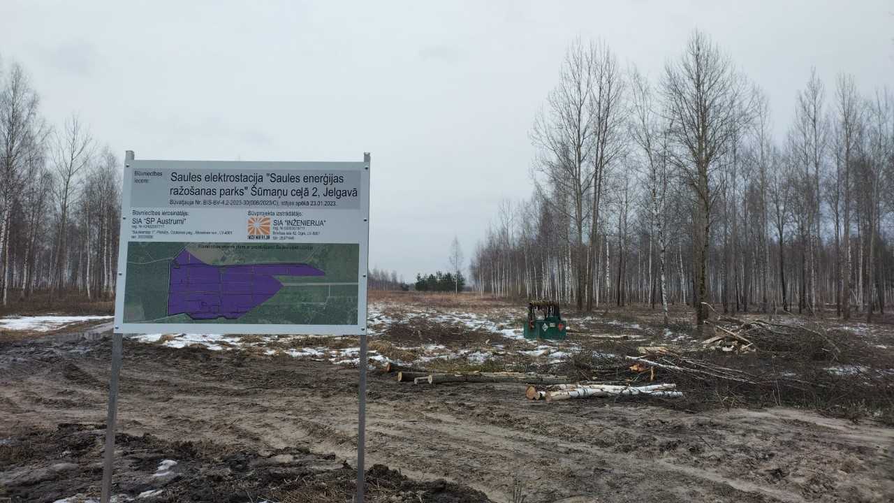
| 174875494 | Sveiki, Šajā izmaiņā gandrīz pilnībā nodzēsti visi punkti plānotajam saules parkam way/1385054952 . Es atjaunoju. Dzēšot citus elementus lūdzu uzmanīgāk pievērst uzmanību, vai tie paši punkti nav arī citam elementam. Arī nosaukums šeit bija pareizs kā redzams https://www.jelgava.lv/wp-content/uploads/2023/04/sumanu_cels_koki_2.jpg |
|
| 162352879 | Čau, vai ar horn=no tu domāji honking=no vai tas kaut kas cits? |
|
| 177573796 | These look just like previous edits in the area by @AK_2 , so possibly the same person. In any case, we are not going to spend the time again fixing and reverting duplicate points, while OSM data remains incorrect while we wait for a reply, so I have reverted these changes. |
|
| 169276126 | That topo map isn't the same as VZD data. I'm not entirely sure how they assemble and edit it and how often (I've never looked into it). I don't think kartes.lgia.lv actually has any map with street lines, because the lines are often messy. You would need to parse https://data.gov.lv/dati/dataset/varis-atvertie-dati or use one of the internal layers from LGIA/LVM WMS service such as [1]. Many roads are represented by just one line, so when in reality there are several parallel roads, it's often down to mapper judgement. For example, the northwest end of that street is actually Stacijas iela, which turns around the corner. |
|
| 169276126 | Those don't have an official name either. Only the main highway has a street name in the VZD street line data. VZD and VARIS are the same "source", broadly speaking. VZD is the state agency that maintains the VAR(IS) address database. For the purposes of SC, these should normally be tagged noname=yes. But, as you say, street signs on the ground are ambiguous, so how could one know. Ideally, we will map all street names from the database directly first, so SC doesn't really need to offer this quest (like they don't offer some other address-related ones anymore in Latvia). From experience, in Latvia may be 1% of street lines have offshoots into side roads. Normally, these are either not named or named differently. There are many crazy streets layouts, but most often street lines are just continuous lines without branching. So if you see the name on the main road, offshoots more than likely don't actually have the same name, at least in the official data. |