GinaroZ's Comments
| Changeset | When | Comment |
|---|---|---|
| 41964354 | Hi, according to OS Locator this street should be "Mackintosh Road" - way/440996668 - which is correct? |
|
| 41966171 | Thanks for adding these - is this complete or should I leave the note open? |
|
| 41886791 | Hi, can I ask why you've created some nodes with just a name and no actual tags? |
|
| 41836126 | Hi, noticed you removed the ref=A199 from the roundabout - what's the reason for doing that? And are you planning on doing it for all the other roundabouts as well? |
|
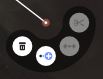
| 41724246 | Hi, if you click on the node in the editor you should get a context menu popup - there is a delete (waste basket) icon on there: osm.wiki/w/images/b/b3/Context_menu_node_on_line.png |
|
| 40855271 | Hi, I noticed you added a duplicate of Latchmere Road, which wasn't connected to anything in a few places. Do you remember why that was? |
|
| 41620424 | I went past there last month, and originally added the pub :) There is an entrance on both sides, but there is only one pub. I placed it in the middle of the building according to the Bing imagery. The operator "Whetherspoon" is a chain of pubs - each one has its own name. You can see the name on the outside of the building on their website: https://www.jdwetherspoon.com/pubs/all-pubs/scotland/stirling/the-crossed-peels-stirling |
|
| 41620424 | Hi, there is already a pub at this location named "The Crossed Peels", not sure why you added another. I've removed it. |
|
| 41537213 | Oh bugger, I didn't see you had added another way for the whole area, ignore me! :X |
|
| 41537213 | There's also amenity=animal_shelter if you want to add it to the dog & cat home osm.wiki/Animal |
|
| 41361138 | Hi, thanks for the edit! Just to let you know, I've made a couple of changes to tidy up your edit. With (cycle)paths you need to make sure these are connected to something at both ends, so software can provide routing directions. You can see what I've changed here: https://overpass-api.de/achavi/?changeset=41387570 Also, I notice paths cross the Lyne Burn at various places - are there footbridges at these points? If you need help or have any questions about editing or mapping in OSM, let me know. :) |
|
| 41321676 | This one: way/216735376 |
|
| 41321676 | Hi Steve, just wondering why you removed the landuse=meadow tag and also changed the fish farm to landuse=agriculture? |
|
| 39485443 | Hi, noticed "Scott's in the Park" is tagged as shop=cafe: way/129914857/history/ - this was changed from amenity=cafe a few years ago. Since shop=cafe is very rare and you were the last to edit it, which is correct? |
|
| 41062321 | Hi, thanks for your edits and helping to improve OSM. :) Just wondering, is the amenity=telephone you added a public telephone? If not, it shouldn't be added. If it is a telephone exchange, it's probably better added as a building. |
|
| 41195913 | Hi. Since it seems like you're local, just wondering if know whether the railway line branching off the Fife Circle to the power station is disused? |
|
| 40627831 | Did you mean to remove the shop tag from this node? node/4055720899 |
|
| 40550714 | It was added in this changeset, seems to have been a conversion from a node to a way http://nrenner.github.io/achavi/?changeset=13963482 |
|
| 40557290 | Are you sure that's the correct location? There's already another museum of childrood nearby... |
|
| 40550714 | Hi, there's a fixme on this way way/172058802 - I assume this has been sorted? |