Beddhist's Comments
| Changeset | When | Comment |
|---|---|---|
| 52153207 | 525686285, 525686289: more tiny tracks drawn unclassified. |
|
| 52185748 | way/294789763 was a residential street, leading off into the paddies. Why did you change it to unclassified? source-GPS usually means the mapper was actually there. Reverting... |
|
| 52153207 | A year later I mapped way/294789776 as a track (using GPS), literally meandering through the rice paddies. 3 years later, what made you change it to unclassified? As far as I can see it's still a track, giving farmers access to their paddies. This is bad. |
|
| 52153207 | In 2013 I drew way/220575744 as a track. You have changed that to unclassified. Seeing that it is quite long and possibly connects a few hamlets this may not be unreasonable, BUT this now implies paved. Looking at both Bing and DGS this is clearly single lane dirt. Can you please show me the image you used to make your decision? |
|
| 55527822 | way/525942419: you connected this to the dirt road in the North. I can't see any connection here on any imagery, so I have removed it. The Northern portion of this is clearly dirt. (fixed) |
|
| 52184823 | Ways 525942409 & 525942546 are clearly dirt, at least the E section I looked at. (fixed) |
|
| 55527822 | way/553800927 is unpaved. (fixed) |
|
| 52047752 | way/524733021: this is an unpaved driveway and you have drawn it right through a building. (corrected) All your roads are offset 5-6m. |
|
| 52049156 | Sorry, there has been a paste error, that way number is not one I commented on. No, I'm not concerned whether a particular track is a road or not. Even on the ground I often can't tell and even my wife can't tell me whether a particular piece of concrete way in our village is a public road or a private driveway. What I am pointing out is a multitude of residential and unclassified roads that are implicitly paved, that are in reality mud and therefore stuffing up routing, or even just planning a trip. Adding surface=unpaved to all of them is a good idea and preferable over a mass-revert. There will not be too many that we need to fix manually after that. |
|
| 52049156 | Ways 524747147, the N-S section of 524747105, 524747145, 524747244, 524747158, 524747157, 524747154, 524747153, 524747160, 524747130 are all dirt. There are probably many more, but for this one a mass-tagging as track is in order. This is what I mean when I say that the map is "polluted" with roads that are mostly farm tracks. You can forget about auto-routing in this area now. |
|
| 55536234 | way/524747198, 524747140 and the W half of 524747146 are dirt tracks. |
|
| 52153690 | way/524747106 is a dirt track. |
|
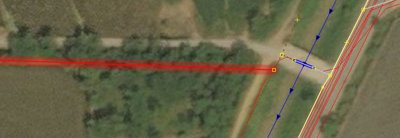
| 52153690 | way/524747170: the Eastern junction does not look at all like you have drawn it: https://i.postimg.cc/wBHxrBg6/image.png Straight across the track and over the bridge, no dog leg. |
|
| 52049156 | Ways 524747117 & 524747118 are both dirt tracks. |
|
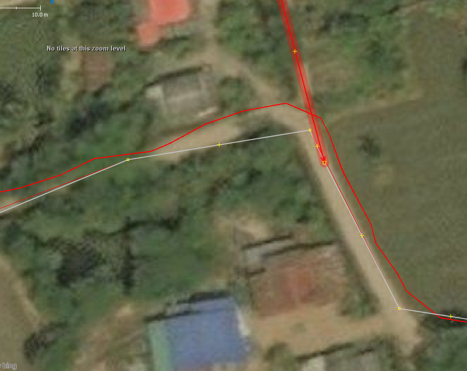
| 55536234 | way/524747236: That's no way to connect a road! https://i.postimg.cc/KjD9cQCk/image.png |
|
| 55536234 | way/524747114 is dirt, clearly visible on Bing. |
|
| 52049156 | way/524747125 is clearly unpaved. This is what it looks like on the ground: https://www.mapillary.com/map/im/OwqAoRkXf0F_J2uKaHjR1Q |
|
| 52159555 | way/525735305: your original classification as track was correct. Pity you changed your mind. Also, all roads are offset by 5m. There are plenty of GPS tracks in this area to correct it with. |
|
| 59187071 | way/590239182: Bing images are 12 years old here, but it doesn't show a connection to สห.3064 and I think it's unlikely that there would be one, as that would make the jct. more dangerous. |
|
| 62566357 | The northern part of way/625378452 looks unpaved to me. That would almost automatically all the side roads unpaved, too. |