Yesterday I mapped two parks along 43rd which I decided would be the final portion - 43rd does continue east of I-435 but in the interest of some kind of coherent boundary to my city mapping, I’m keeping it within the bounds of I-435. The parks had several amenities like sports courts, picnic shelters etc. On the way between one park and another, I encountered a bar owner who wanted to chat. He noticed me taking a photo of a downed pedestrian signal button and complained about all the accidents that happen outside his bar - including the one that led to that particular damage. I reported it on the city’s 311 app and asked him if he was aware of the app - he wasn’t, so I showed it to him in case he wanted to report more accident damage in the future. A kind old man driving through one of the parks asked me if I was with Parks and Rec, and said he hoped they would add a public restroom to the park one day. I told him I agree, but explained I was just doing a hobby and not with Parks and Rec.
Diary Entries in English
Recent diary entries
Several times when I have added milk churns stands to the map in Latvia, I have noticed ponds in the vicinity of farms. For a while, not knowing much about Latvian culture, I thought they were for keeping fish for a balanced diet.
But today, after having added two more MCS, I decided to ask my trusted Latvian on Instagram, the lady who has the account which features Latvian milk churn stands. She explained that rural farms often still have a sauna and that people also like ice water bathing, so it’s convenient to have your own pond on the farm. The little sauna hut (not mapped much in Latvia, but in Finland as building=sauna, building:use=sauna and building=sauna_hut) is often surrounded by trees and a bit away from the farm house in case of fire.
I had added a few ponds here and there, but I’m delighted to see how many are already mapped in Latvia - over 14,000!

Every day is a school day.
Mapping and Geoprocessing Course with QGIS (online / 100% Free)
Curso de Mapeamento e Geoprocessamento com QGIS (on-line / 100%
Gratuito)
This is an extension project of the Geography Course at UNESPAR (State University of Paraná), with the purpose of qualifying participants in mapping and geoprocessing using QGIS. This course is certified (up to 60 hours, according to participation) and in this way, we wish to bring knowledge to teachers, researchers, students and the community in general, always in need of new skills to assume their space in the workplace.
CONDITIONS TO TAKE THE COURSE: Have a computer (with good storage and processing capacity) with internet access;
Have basic computer knowledge (know how to unzip a folder in Windows, copy and paste procedures, etc.);
Be able to attend online classes on Sunday mornings (once a week). Set aside one day a week to watch the theoretical video lessons and practice;
participate in a TELEGRAM group, to ask questions and receive information relevant to the classes (invitation link https://t.me/+OqUWHvvnQldjYjgx);
Participate in the (online) classroom;
It is recommended to use a handheld mouse.
REGISTRATION LINK: https://encurtador.com.br/afFY1
DATA: From March 10th to May 19th, Every day from 9:00 am to 11:30 am Horário of Brasilia.
Hello hello strange website I do not fully understand! I have begun mapping out my Town! The grand town of Northampton! I saw a lot of the suburbs, and even parts of the town centre were missing residential housing features, so I began adding buildings on a road I know quite well as I used to live there. I know I missed a few sheds, but I am not about to guesstimate their locations under trees. Cheers!
I’m just back from a holiday in Malta where I obviously mapped a lot. I made it to #3 in number of changesets in the country which was not terribly difficult.
Something went wrong with my SIM card as soon as I landed, so I had no mobile internet, but I had downloaded Malta on OSMAnd beforehand, so I was good. And there is free wifi on public transport which I availed of excessively.
I added and modified all kinds of things: post boxes (also updated collection times which seems to have changed generally on the island of Malta to Mo-Sa 7:00), defibrillators, ferry terminals, shops, museums, bus stops, charging points, and because it’s me, jostle stones, urine deflectors and drawbar slots. In Mdina, I could actually see the jostle stones in action! I was so excited, I made a little Short for Youtube, but that corner didn’t have a guard stone, but was chamfered and had a metal protector: YouTube Link
Looking at neis-one for Malta and looking up some of the mappers, it seems that Malta is mostly mapped by tourists and these days. You can tell (at least it was my impression) that by what is mapped as well: Areas that are frequented by tourists are mapped much better (I added some post boxes that I spotted from the bus going through areas where tourists don’t get off the bus). Things that are of interest to tourists are mapped, like museums, hotels, bars, beaches and shops whose brands are known globally.
Even before I had set off, I had noticed many hiking trails mapped. I only tried out one heritage trail, and found it poorly signposted. If I hadn’t had the route marked out on OSMAnd, I wouldn’t have known where to go, I think. I noticed some bits missing in the relation and contacted the original mapper who turned out also to be a German tourist. I added some of the other features along the trail. I don’t know who mapped the other trails; I had initially thought that maybe the tourism department of Malta had done it, but I haven’t looked into it.
Motivation and Scope
Workflow to map points of interest (POI) in OpenStreetMap (OSM) from a comma-separated values (.csv) file and generate a dynamic web map.
It is important to highlight that this procedure can be carried out by novice mappers and that it is more suitable for mapping little data, for example, schools, health posts, emergency sirens etc., confined to an area that could be, for example, downloaded with iD or JOSM.
To import a larger volume of data into OSM, you need to be an experienced mapper (intermediate or advanced level), to document the procedure on the OSM Wiki and to obtain community approval. This case is not the focus of this tutorial.
Materials
For this activity, you will need:

As we announced at the beginning of 2023, OSMCha has become a charter project of OpenStreetMap US. After almost 10 years of being generously hosted by Mapbox, OSMCha is now moving to a new home at the OpenStreetMap US. Going forward, OSMCha will be run on infrastructure owned and operated by OSM US. We are excited about this new chapter for OSMCha and to work with community members and organizations to grow the project.
In the last few months, the Development Seed team has been working on modernizing the infrastructure code behind the OSMCha services, closely working with Mapbox. As the infrastructure built by Mapbox was designed almost a decade ago, this was a required step to execute the migration. It is also bringing more efficiency in terms of cost and performance.
The migration will be done next Tuesday, February 13th. Starting from 15:00 UTC, OSMCha’s API will be read-only or unavailable for a few hours.
We are grateful for the support provided by Mapbox throughout the years. Mapbox was the first company to believe in the OSMCha proposal, funded the initial development and continued running the project providing infrastructure and critical maintenance. Their support was crucial in making OSMCha a core tool used by the OpenStreetMap community, everyday. We are now seeking new partners to help us continue to develop and expand OSMCha. If you’d like to support OSMCha directly, you can contact the OpenStreetMap US staff at team at openstreetmap.us.
Mapping and Geoprocessing Course with QGIS (online / 100% Free)

Curso de Mapeamento e Geoprocessamento com QGIS (on-line / 100%
Gratuito)
This is an extension project of the Geography Course at UNESPAR (State University of Paraná), with the purpose of qualifying participants in mapping and geoprocessing using QGIS. This course is certified (up to 60 hours, according to participation) and in this way, we wish to bring knowledge to teachers, researchers, students and the community in general, always in need of new skills to assume their space in the workplace.
CONDITIONS TO TAKE THE COURSE:
-
Have a computer (with good storage and processing capacity) with internet access;
-
Have basic computer knowledge (know how to unzip a folder in Windows, copy and paste procedures, etc.);
-
Be able to attend online classes on Sunday mornings (once a week). Set aside one day a week to watch the theoretical video lessons and practice;

Ever since visiting Mount Lassic and then making edits in the region, I’ve had this nagging difficulty: What to do with a mountain whose high point is named differently? Mount Lassic has three peaks, the highest is called Signal Peak. I eventually mapped its survey point, which is also called Mount Lassic, and hoped that was done. (Apparently I shouldn’t map survey points except at the exact point indicated, so I’ve done this WRONG. I’ll just name a peak “Such-and-such Benchmark” then. Except a benchmark is specifically a vertical control and most at peaks are horizontal controls. “Such-and-such Triangulation Station” gets a bit long. Oh, the humanity!) Unfortunately, if one searches for the mountain, one only gets the Mount Lassic Wilderness and the Mount Lassic Trail, but there’s no hint that this goes to the high point of Mount Lassic. It goes, in fact, to “Signal Peak”.
Other places where there’s a named high point (peak) different from the main mountain are Marble Mountain (with Black Marble Mountain the high point). Someone seems to have simply marked a lower peak as Marble Mountain. If one does this, there’s a bit of a debate if it is the highest white peak or the most prominent white peak. Mount Konocti with high point Wright Peak. Currently both are marked close to the high point, but the main mountain has been given a lower elevation so doesn’t show often, but it is searchable.
Yesterday, I reached the point of one million map changes and twenty-thousand changesets. Leading up to this milestone, I tracked my progress on How did you contribute to OpenStreetMap? and carefully planned to make a single edit that would be my one millionth in my twenty-thousandth changeset. I eventually made a gimmicky changeset referencing my first mapping experience. Mission accomplished! However, despite the impressive numbers, my initial sense of accomplishment faded, replaced by nagging existential questions. Have the countless hours I devoted to OSM truly been worthwhile? Why have I been doing this? What is it exactly that I have been doing? … What is OpenStreetMap, really? And there it is, a question that seems very simple, but is not. It is the same question that hides far below the surface in Xvtn’s OSM Iceberg Meme. Inspired by this meme, user rtnf put it this way: “Is it a map? A dataset? A community? A trademark that encompasses an entire ecosystem consisting of the dataset, the tagging scheme, the rendering infrastructure, and the subculture around its mappers, developer-mappers, and third-party data consumers?? What is OSM, really?”
When you invite someone to go to openstreetmap.org for the first time, the first thing they read is “OpenStreetMap is a map of the world”. The next thing you usually want to explain to them is that OpenStreetMap is NOT (just) a map of the world. We then continue showing off different rendering styles, different editors, different tagging schemes … We pride ourselves being part of a secret society, where only the sworn in know what it is actually about. We giggle when we see the Iceberg Meme because it is “so true”. We say things like: “If you have been doing this for years, you will understand”. All of this without being able to answer a very simple, fundamental question: What is OpenStreetMap?
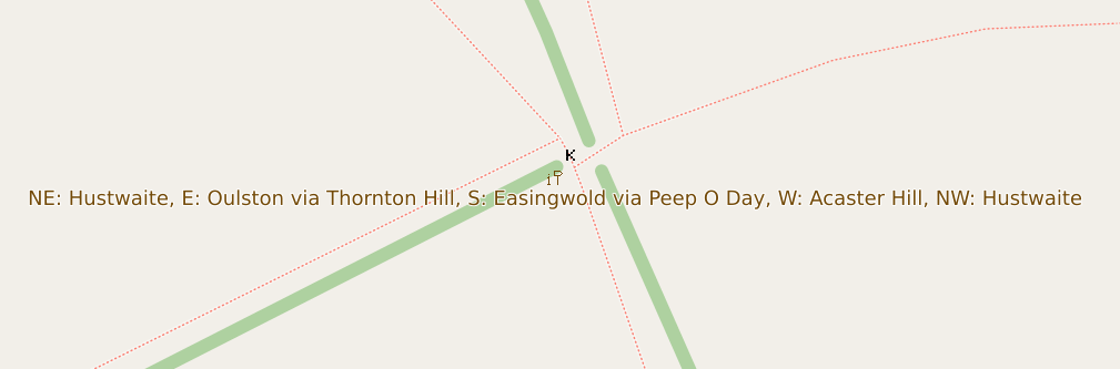
Although the raster maps at maps.atownsend.org.uk support zoom levels up to 24, until recently I’ve not made much use of that for showing extra data. However, there is a lot of room at these high zoom levels - as the picture above shows, enough for all the directions on this signpost here.
The name is shown as normal at lower zoom levels, then as you zoom in the directions are shown too, as you can see here.
1st Time Learning about QGIS and Open Street Map through Digital Mapping Workshop on Palang Merah Indonesia (Indonesian Red Cross), North Jakarta Branch

Whilst attending FOSDEM in Brussels this week-end. Of course as I’m European I was able to use streetcomplete while roaming. So I did and collected a bunch of bagdes. While spending time with a friend, as we were walking to get/find food, I was playing. When I explained what I was doing, he got immediately interested in joining, so I demoed a bit more and had one more person going to map around his home.
I’m Harrison, a hobbyist mapper based in Brooklyn, New York. I’ve been a map lover for as long as I can remember. Over the last few years I have gotten more involved in OpenStreetMap including my first trip to State of the Map US last year.
Mapping Projects
My ongoing “forever” project is mapping sidewalks in Brooklyn. With about 1,600 miles of roads there’s a long way to go! Beyond just mapping sidewalks I am working on adding curbs with accessibility details.
My most interesting mapping project has been working on the map at Train Mountain Railroad, the world’s largest miniature railroad. This started out as armchair mapping from home, then when I visited this last summer I worked on Mapillary “rail-level” imagery and other detailed mapping. The most exciting part has been the engagement from the community at the railroad getting engaged. The improved map has been immediately useful in the Train Game, and is being incorporated into a new track guide. This project has been fantastic as a complete study from all kinds of mapping to end data users.

EN:
A lot of new mappers are trying to edit existing element instead of creating new one and set properties to them. (For example some new mapper added amenity=pharmacy to whole apartment building insted of creating one node for it.)
Also I think it would be good idea to hide some existing layers for newies (at least boundaries). New mappers do not need to work with them, because they are not changing for a lot.
In iDeditor a lot of times happens that new mapper connect road with forest boundary, because he just moved node on way for a bit and iDeditor connected this 2 elements (This can be prevented by holding Alt, but new mappers do not know this). So we can at least think about layering OSM at least for new mappers.
Also when new mapper is crating new way, which is going in the same direction as some existing way (boundary or forest boundary) he many times connect this new way with existing one.
Proposed layers:
- POI
- buildings, highways, railways
- landcover
- boundaries
In JOSM I’m using filter to hide landcover and boundaries for most of time. Only when I want to work with landcover or boundary, only then I revert filter to show only this type of ways.
SK:
Čím viac sa nad tým zamýšľam, tým viac mi to príde vhodnejšie. Veľa nováčikov sa snaží niečo pridať, lenže väčšinou len upravia existujúce elementy namiesto toho, aby pridali nové. Taktiež si myslím, že by bolo vhodné nováčikom skryť aspoň hranice. V iDeditore sa nováčikom často stáva, že spoja cestu s hranicou lesa (Nevedia, že keď podržia Alt, tak sa im to automaticky nespojí). Takže môžme aspoň pouvažovať nad nejakými vrstvami v OSM.
Navrhované vrstvy:
- POI
- budovy, cesty, železnice
- lesy, lúky, polia …
- hranice
V JOSM mám väčšinou zapnuté filtre na skrytie landcover a hraníc. Iba, keď potrebujem elementy tohto typu editovať, len vtedy si filtre prevrátim.
it’s me again speaking from beyond the grave lmao!, todays diary entry consists of a bait and switch a user is trying to do first by removing a simple note from South Australias Major Traffic Network, and therefore after based on “Whats on the Ground” change the classifications of the road network to whatever the user feels. The problem with this is that “Whats on the Ground” literally has no authority over “actual nature of the road”. If this does not make sense please read the community link below.
https://community.openstreetmap.org/t/automated-edit-to-remove-note-on-highway-trunk-in-sa/108612/12
Previous diary placeholder
Improving the data within OSM around Beacon, NY and surrounding towns.
Specific road, sidewalk, and bike focus. Improve data about existing buildings and building changes. Improve trail network and information.

Don't map for render
Don't map for geocoder
Don't map for validator
Don't map for database
Don't map for Overpass
Don't map for editors
Don't map for laws
Don't map for statistics
Don't map for yourself
Don't map! Soon the AI will map it all out.
Map often
Map early
Map in the mornings
Map at noon
Map in the evenings
Map late at night
Map from dusk to dawn
Map on weekends
Map daily
Map every day in your heart
Map your town or city!
Map what you like
Map where you go
Map whenever possible
Map who you love
Map obscure and rare tags
Map for yourself
Map for humanitarian causes
Map alone
Map together
Map to your heart's content
Map for Light, Life, Love & Liberty
Map !