OpenStreetMap logo OpenStreetMap

Diary Entries in English

Recent diary entries

Posted by Pieter Vander Vennet on 14 September 2022 in English. Last updated on 15 September 2022.

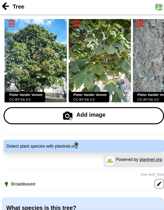
PlantNet.org offers an API which tries to determine the plant species based on some pictures.

I integrated this API into MapComplete, together with some queries to Wikidata. As a result, linking a tree to the correct species identifier is easier then ever and can be done with a few clicks:

Posted by Zverik on 14 September 2022 in English.

How Every Door looks while mapping a mall

This week I’ve released the 2.0 version of Every Door, which irons out most of the inconveniences found within a month after its official release. Yes, the editor has been officially released, just a few days before two talks on it at SotM and FOSS4G (recordings pending). You should download the editor for your Android or iOS smartphone right now!

I absolutely love the experience it gives me. It has revived my love for plain mapping, going out and collecting things to put on the map. Pascal’s HDYC shows my mapping days went from 29 last year to over 120 this year. That’s because I again look around for unmapped things while outside, and making an edit no longer requires navigating a map on a small phone screen, or making scribbles to open JOSM later at home.

See full entry

(Sorry for the delay in posting. I spent most of July 2022 on holiday in Australia)

  • Mapping
    • Livnig in Germany, I’m used to lots being mapped. In Australia there was so much to map!
      • I got to rank #151 in Australia (🐦 🐘) just from my day to day mapping.
      • To my shame, I did use Google Maps. There was so much missing PoIs from OSM.
    • A shop (which I spent a lot of money in) was selling dresses with “he/they” pronoun badge, and I wondered if clothes=women still applied 🐘 🐦. 🤣
  • OSMF Board
    • Board Meeting, July 2022 Board Meeting
      • I had just retured from Aus, and the postponed community presentation from Mapbox Workers Union was interesting.
      • It was interesting to find out that the Mapbox management hadn’t put any direct or explicit pressure on employees to vote a certain way at OSMF Board elections
      • Lots of Mapbox based maps don’t show OSM Attribution, and it was interesting to find that the union had tried to change that internally.
    • I didn’t go to the 2022-07 mid month chat because I was away in Australia (timezones!).
    • I started the wiki page for the board AMA at SotM 2022
  • Community
  • CWG
    • Freebies / Promotional Material Programme
      • I’ve been so bad with this lately, I’m sorry. I have requests from months ago that haven’t been sent out.
    • Instagram still posting there
    • Pinterest haven’t posted there as much lately.

Previously…

See full entry

Posted by mvexel on 13 September 2022 in English.

Ilya wrote about the 10th anniversary of OSM adopting the ODbL license yesterday. He has a cool 2012-2022 map compare web site to go with it. It’s incredible to see what we, the OSM community, have accomplished building our map in 10 years.

Ilya is a pretty technical guy and it’s not a huge thing for him to set up an OSM tile server from scratch. But what if you want to create something similar and you’re perhaps not quite that technical? If that’s you, I have something you might be interested in! It’s a little open source project on Github called openstreetmap-vintage-tile-server. With it, you can create a side-by-side map in a few pretty simple steps. The README on Github explains it pretty well, so I won’t repeat it here, but the steps are basically:

  1. Make sure you have docker and osmium installed
  2. Download a full history planet for the area you’re interested in (Geofrabrik has these, but you have to log in with your OSM account)
  3. Run the script

When it finishes, the tiles should be available on your local machine. The script will give you the URL to go to. There’s also an HTML example that you can use to create an interactive side by side map like this:

See full entry

Location: Central City, Salt Lake City, Salt Lake County, Utah, United States
Posted by Roberto Boberto on 12 September 2022 in English. Last updated on 13 September 2022.

Hi from Syria

I’m very impressed by the achievements of all the OSM contributors and as an IT student it was very nice to see how all this tooling is open-source.

I found OSM while searching for alternatives to Google Maps, that’s mainly because our country is sadly under restriction from the high majority of services provided by US companies.

And even if it was not for the restrictions, it would be for the price.

So I’ve found OSM and started diving step by step in it’s wiki. Until I was able to understand how the map can be mirrored, rendered and customized.

Then with some checks of my local area I wanted to do some edits as an experiment and oh god the tooling is amazing.

Huge thanks for everyone who worked on OSM whether on it’s software, organization or even contributed to it’s database!!

As a start I marked some appartement buildings, lets so how this goes.

Posted by Zverik on 12 September 2022 in English.

Dar es-Salaam in 2012 and 2022

Ten years ago on this day we changed the license for our data to ODbL, Open Database License 1.0. That was the final action of the lengthy relicensing process, which followed an exciting show of redacting and remapping the planet.

In July 2012 we started every day with watching the redaction progress map, discussing how the redaction bot devoured our precious map data, and making memes on the way.

After the bot finished its work, we started remapping everything we had lost. Poland and Australia were particularly broken, but most other countries had their losses. Alas we could not make everybody agree to the new contributor’s terms, so some mapping had to be done twice. But the work went better than expected, and it was then when we felt that the community is more important than the map, and that OSM can survive the loss of the latter.

See full entry

Namaste from Nepal,

Even though it has been two weeks since I returned from the conferences, the memories still seem fresh. When I reflect back, I am filled with so many new experiences and learnings that will be hard to cover in this diary but I will try to summarize in highlights so that it’s not boring for you :).

First day at Florence

Landing in a new country for the first time far away from home, was an overwhelming journey. I want to express my gratitude to Poorni Badrinath and Hector for helping to make my first day in Florence easier. Before I could check in, they showed me about the city, and after waiting in line for at least five minutes, I got to enjoy the best sandwich in popular place called All’Antico Vinaio. Oh, the first day went much better than I had anticipated. And, the next day, SOTM started. The idea of badges for talking accessibility really amazed me. Kudos to the creativity! first day with amazing Poorni

SOTM 2022

See full entry

Location: Kathmandu-02, Kathmandu Metropolitan City, Kathmandu, Bagamati Province, 21255, Nepal
Posted by tareqpi on 11 September 2022 in English.

Hi everyone, this is the update on the final phase of my progress in enhancing Nominatim’s search results ranking.

Previous Diary Entries

To have a background understanding of the project, you can check the overview of the project followed by the project’s first phase down below.

  1. Project Overview
  2. Phase 1

Project’s Pull Request

To see the code of the project, you can check the pull request here.

Detailed Report of the Project

The detailed version of the report can be read here.

What Has Been Done

  • Enabled PostGIS to work with raster files
  • Nominatim CLI tool can now import OSM views data from the GeoTIFF file
  • Nominatim CLI tool has the ability to refresh the OSM views data and recompute the importance scores
  • Integrated OSM views data into the algorithm that computes the places’ importance scores which are used in ranking Nominatim’s search results
  • Added some unit tests
  • Updated the documentation and added a detailed report of the experiments conducted

Possible Next Steps

There is a weak correlation between the OSM views data and the wiki importance data. A number of possible reasons have been outlined in the detailed version of this report in which further investigation is needed to have a better understanding of this outcome. Apart from that, the OSM views import feature can be enhanced so that the user can specify the zoom level when importing the data, or even have multiple zoom levels data imported one after the other so that the OSM views data have a higher degree of accuracy.

What I have learned

See full entry

Location: Taman Tun Dr Ismail, Kuala Lumpur, 60000, Malaysia
Posted by giggls on 11 September 2022 in English.

Recently I started an attempt to make the campsites shown on https://opencampingmap.org googleable.

One part of this attempt will be an indexable list of campsites by country.

However, the main trouble with this seems to be broken mapping which will make the generation of such a list really cumbersome.

As an Example I came across this place: osm.org/way/335229905

There are multiple problems with this site in its current form. I will fix them later but use it as an illustration for a broken site first.

The main problem here are nodes tagged tourism=caravan_site and tents=yes which reside inside two polygons tagged tourism=camp-site.

As an example we have a node tagged:

  • name =C11
  • power_supply=yes
  • tents=yes
  • tourism =caravan_site

The way this node should be tagged instead is:

  • tourism=camp_pitch
  • caravans=yes
  • tents=yes
  • ref=C11
  • power_supply=yes

Please do never map individual pitches as tourism=caravan_site or tourism=camp_site. Use tourism=camp_pitch instead.

This said, in this case even the two polygons are not individual camp-sites themselves.

What should be done instead is merging the two polygons tagged tourism=camp_site (osm.org/way/335229905 and osm.org/way/335229904) into one multipolygon with two outer rings as we are obviosly talking about one single campground rather than two. I also consider “Campground Loop A” a feature of one of these rings rather than its name. So best would be using the description tag on the to be created rings then.

The name tag of the to be created Multipolygons should then be Fort Pickens Campground which is surprisingly tagged on none of the objects currently.

I do not have local knowledge of this campground but there may well be camp-site features outside these polygons.

The way to map the site in this case would be a site relation. I wrote about this in my blog some time ago: https://blog.geggus.net/2021/09/announcing-support-for-site-relations-in-opencampingmap/

Project Abstract

The primary aim of this Google Summer of Code project is to re-introduce transit support in Valhalla, the OpenStreetMap based Routing Engine. Initially, Valhalla supported a mode to route transit, but due to a bottleneck from a third-party library, it became unviable to continue support transit routing. Therefore, the aim of the project is to directly parse raw General Transit Feed Specification (GTFS) data and remove the dependency.

The high level overview of the project is visible here:

GitHub Project

Specific details of each pull request will be described below.

What has been done

The first stage of the project was importing GTFS and ensuring that we can parse the data. GTFS is a set of text files, and rather than iterating through them manually, I decided to use a third party library to automize the read-write process. Just_gtfs allows us to read and store transit data in variables rather than manually trying to parse text. Moreover, I can create sample test data without being concerned about creating invalid data.

After parsing GTFS data, the next step was to pre-process them so that they could fit into Valhalla’s existing data format. Firstly, since the map is divided into tiles – square regions of equal area – I sorted the data according to which tile it belongs to. Tiles are beneficial to save computing power because only the information that belong inside the tile need to be processed when routing through small regions.

Parsing GTFS Pull Request

The sorted data then needed to be built into protobufs, which are used as intermediary data storage before they are converted to tiles. Protobufs are much more condense and versatile than raw GTFS data, so we extract the relevant information from GTFS into protobufs and gather the data. This is further useful because instead of iterating through each stop or trip of a tile, the tile could be read as one whole entity, streamlining the reading process.

Creating Protobufs Pull Request

See full entry

Location: University, University—Rosedale, Toronto, Golden Horseshoe, Ontario, Canada
Posted by matheusgomesms on 10 September 2022 in English. Last updated on 11 September 2022.

Original post in Portuguese here

After some time from the return of State of the Map 2022 in Florence, and after a brief reflection on my experience at the event, I would like to share my views on SotM 2022.

Duomo View

Initially, I would like to thank the State of the Map Working Group for providing grants to participate in the event, which I was awarded (more on this later).

About the event, it was 3 very intense days (and sometimes overwhelming)! During SotM, I thought I could enjoy it more, but looking back, I see that it would be practically impossible. Several very interesting presentations at the same time, amazing people to meet and talk to, very well constructed and presented posters, in short, a lot happening at the same time.

See full entry

Location: Meireles, Fortaleza, Região Geográfica Imediata de Fortaleza, Região Geográfica Intermediária de Fortaleza, Ceará, Brazil

versão em português

In these last 2 years as a full time volunteer, I have developed several mapping projects around Brazil, because I believe it is my duty to contribute because of the deficit the map had in my region. My goal as a mapper is to try to decrease the blank spaces in OpenStreetMap so that more people can use them and thus more mappers emerge.

I understand that not everyone has time or interest in mapping, the most they can do is the basics, and many times they forget about OSM because they can’t use it on a daily basis, even more in a country like Brazil where hardly a worker would have time to be updating maps.

I have dedicated myself daily to OSM, but unfortunately this has a cost and since I am no heir, it has been very difficult to reconcile my volunteer work and my personal life, I have gone through some very complicated phases since I decided to dedicate myself full time, but I also had a lot of help.

Working at OSM is not an easy task, because your work is never finished, there are always new changes that need to be mapped, mistakes to be corrected, it’s a continuous job that requires a certain level of knowledge and experience acquired over time.

One of the first projects I did was using DAMN and then Taskmanger to be able to manage and map entire cities, with this project almost 20 cities were fully mapped from roads to buildings.

See full entry

Location: São Benedito, Timon, Região Geográfica Imediata de Timon, Região Integrada de Desenvolvimento da Grande Teresina, Região Geográfica Intermediária de Caxias, Maranhão, 65630-970, Brazil

It was a joyful moment, having been selected and given a scholarship to attend the hybrid conference, SOTM 2022 in Firenzi Italy, first time to board a plane so it was a whole lot of new experience and excitement, I arrived in Firenzi on the 18th of Thursday evening just in time for the event. The historical city of Firenzi is a beautiful city with a whole lot of sculpture, just like what I see in the movies. text

See full entry

First stop, Cercedilla

The Spanish government has decided to fully subsidise the regional train services around major Spanish cities for the rest of the year, to try and encourage people to use public transport more. Now I don’t use Madrid’s Cercanias services very often, because I work mostly from home, but I decided to get my free ticket and explore the region a bit more. Then it occurred to me that I could also take advantage of the offer to do a bit of OSM mapping in different places.

So yesterday I got on the train and headed to Cercedilla, sitting at the foot of Madrid’s mountains. It’s a station I have been to many times, but always to start a hike - you can walk straight out of the station and onto a trail that takes you up to those mountains. This time I headed for the nearby village, gathering addresses and points of interest as I went.

I was giving a test run to the Every Door application, presented by Ilya Zverev at this year’s State of the Map event in Florence. It worked very well for capturing the points of interest, the address and building interface was a little trickier to understand - but I liked it and will use it again. I need to check whether I can configure it a bit more so that I don’t need to add so much to the data later at home. But I can stop being the mapper with the old Garmin GPS for a while.

More OSM away days around Madrid will come, the free ticket lasts until the end of the year!

Location: Trescasas, Cercedilla, Community of Madrid, 28460, Spain
Posted by poornibadrinath on 8 September 2022 in English.

It is always amazing to connect with like-minded people on topics you are interested in and talk about making it better. That’s what State of The Map has always been to me. And this time, thanks to HOT UnSummit, I got a chance to attend one as a student, and understand the use cases of maps from a very fresh perspective.

After more than 5 years of working in the mapping sector, I decided to pursue my Master’s in Cartography and being a student again, both of the conferences of SoTM and FOSS4G proved to be very beneficial to attend and understand the ways the mapping community are branching out in.

Alt text

I have been a part of the SoTM community for a few years now and have got a chance to even present some of the talks on OSM and validation. However, the whole experience at Florence this time was very different and engaging. The first in person conference after COVID, it was fantastic to meet everyone I knew in person and connect on maps and more.

See full entry

Location: Innere Altstadt, Altstadt, Dresden, Saxony, Germany
Posted by Zing929645 on 7 September 2022 in English. Last updated on 19 September 2022.

Introduction to JOSM Route Visualization

Hi, this diary is for showing what I have done in GSoC 2022. Two months went so fast that I suddenly realize the final date has come. But I still want to follow the guidance and try something I haven't done before, and I can't wait to show the power of this plugin and some new functions that help.

JOSM route visualization plugin is for displaying the full picture of the public transport routes, which is convenient for users to query and greatly improves the efficiency of route maps and members modification.

Checking the relevant function, you can open the relation editor of some route or public transport objects , and then grasp a big picture of the distribution of routes by specially enhanced image instead of a list of way members. In the meanwhile, the path-finding algorithm and logic handling is great for users to choose the next way to extend existed routes from given options rather than add ways needed manually.

Previous Posts

Greetings

Progress in First Half

First Half Summary

  • Fix the problem that target route figure is under the layer of other irrelevant models.[merge_request1][merge_request2]
  • Make the ways under the route relation of same type as the selected relation of route more evident and add waterway features.[merge_request2]
  • Mark the selected stop in main window[merge_request3]
  • Listing distance from next and previous stops and relation routes in the dropdown of clicked stop[merge_request4]

Second Half Summary

  • Add turn restriction to guarantee path-finding logic to avoid ways it shouldn't be turning to. [merge_request5]
  • Add access restriction to guarantee path-finding logic to avoid ways that have no permission for route extension according to transport mode match.[merge_request5]
  • Handling Roundabout[merge_request6]

Effect Contrast (Part of visual effects display)

Target route floating problem:

See full entry

Location: Allston, Boston, Suffolk County, Massachusetts, United States
Posted by david_daish on 6 September 2022 in English.

Removing duplicate bike paths, updating details of bike paths, and improving routing information is fun! The Sockburn roundabout and bridge is one of the most hostile places for bikes and pedestrians I have ever visited. In the process of surveying it with a fieldpaper map, I almost got hit a few times. To be fair, I was biking with one hand, the other was holding the map XD. I sent an email to the CCC asking if they were intending to improve it.

Adding businesses in the Upper Riccarton chinatown area was great fun! It adds so much texture when you really get down to the fine details. Such an interesting place that I never hear people talk about. I really recommend Ramen Miyako, it slaps.

Location: Upper Riccarton, Christchurch, Christchurch City, Canterbury, New Zealand
Posted by Hawa Adinani on 5 September 2022 in English. Last updated on 8 September 2022.

My motivation for attending the conferences was to share the local perspective of open mapping communities and learn from other communities on how they uphold diversity, sustainability, and impact in solving challenges in their communities. I’m grateful to unSummit scholarships for covering all of my travel expenses so that I could participate in this global gathering! - It was worth it.

I was impressed to see and meet the diverse groups represented at the conference, as well as to see that the majority of grantees (both from Unsummit and FOSS4G grants) come from underrepresented communities, which made the conference more interesting - I met and connected with people from different corners of the world… Peru, Fiji, Brazil, Cape Verde, Jamaica, Guinea, Vietnam, and others who have different ideas about open mapping and how they use geodata to solve local community challenges.

SotM was incredible…there are so many applications for OSM data, and they vary greatly from north to south. SotM was also full of community talks and how OSM communities are leveraging data to solve problems in their communities: all of the talks that I attended were excellent, but my favorite was Florian’s talk titled “How to Kill OSM.” (https://2022.stateofthemap.org/sessions/A8JLUY/) - in my opinion, he had great ideas about OSM’s sustainability thinking.

FOSS4G - a more diverse participation, i.e. academia, developers, users, community, business people, and so on: sometimes I would reconsider approaching someone, worried that they would open their computers and run scripts to explain what they do - haha (you should know by now that I am not a technical person, I enjoy working with them though) - but I still enjoyed every minute of the conference with amazing workshops and talks.

See full entry