In my quest to know more about mapping, I took some courses on the Youth Mappers platform. It was worth it. Although I already know how to do some of the things taught, but it helped finetune my mapping skill. I look forward to taking other courses, especially on how to validate a task.
Diary Entries in English
Recent diary entries

There must be another name for these. There has to be a tag for them. They’re so common!
But I see in highway=trailhead that a “trail register” is something you might want to tag exists at a trailhead. Yep. How? It doesn’t mention that.
Trying to dig about and find what others have decided on their own. I found some
tourism=information
information=route_marker
name=Trail Register
in New York. In another cluster of two are some
tourism=information
information=board
name=Trail Register
I’ve seen some in the Wind River Range in Wyoming that were built into the information board. I guess it could be an information board with a register. It’s not a route marker. In fact, the one I’m staring at at the moment is at the parking which is somewhat offset from the actual start of the trail. Look, it’s a ridge. There’s room here and the trail is over there. Deal.
In Connecticut, I’ve found a single
tourism=information
information=route_marker
trail_register=yes
so there’s some more support for calling it a route marker. It’s not! It sorta can be. But it’s not!
I’ve found a
tourism=information
information=trail_register
in southern California similarly in Iceland
information=trail_register
man_made=cairn
name=Arnarfellsbrekka
and, I mean, what? I guess maybe a named cairn could have a register. Certainly cairns and peak registers go together. Those are usually a little less official than the registers at trailheads.
I have to admit, this simpler one seems best. I see why people are attracted to putting this down as tourism=information since the comments people leave are often the best source for information about the trail conditions you are about to experience. I may have accidentally weighted my search for this tag, though. Not all of it, but the later of it.
So one can do user defined values for information=, one does not have to choose from the small selection in the wiki. I’m going with…
tourism=information
information=trail_register
Background
For a long time, I’ve used the OpenStreetMap as my main driver for online maps. Whenever I’m hiking, the route or big parts of it are planned according to OpenStreetMap, walking from viewpoint to viewpoint.
A few years ago, I made some tiny contributions to the maps in Leiden where I live(d). As The Netherlands is mapped rather accurately and there are a lot of active people in this country, it only stayed at a few minor contributions.
That changed when I moved to Bonaire a couple of months ago. Bonaire is a small island in the Caribbean. In the past ten years, the population doubled and a lot has changed.
Contributing
Some of the contributions so far include:
- Adding hiking trails;
- Adding streets, street names & amenities;
- Adding development projects;
- Resolving open map notes. A lot of map notes have been added over the past few years mentioning that certain amenities are no longer there, or a request to add them. I’ve resolved now almost all of these notes (and of course an RSS subscription is notifying me of any new ones that may arise).
Adding trails is a lot of fun since it’s just enjoying a walk with your phone set to record a track, and thereafter importing the GPX file etc. Adding street names and amenities is a bigger challenge since you need to constantly be writing these things down in your phone.
Challenges
There are several things that make mapping sometimes a bit of a challenge. The available satellite images/aerial photos from Bonaire are either cloudy or outdated (or both). Even with a detailed GPX track and notes from my phone, it’s in some cases difficult to add stuff at the right place if the satellites images are too old or too vague.
Posted by arjunaraoc on 3 July 2023 in English.
Last updated on 5 July 2023.
I added 52 fuel filling stations which is 11.5% increase over earlier count of 451 across Andhra Pradesh. I spent about 10 hours logging the points of interest (POI) and another 10 hours updating them. Here is my backstory or how-to-do guide.
 I have been an OSM mapper from 2015, having learnt basics from PlaneMad and received mentoring from Heinz Vieth. I have been mapping occasionally about my neighborhood and places that I visit. I also installed Osmand on my smartphone and explored its navigation and trip and POI recording features. In my recent trip to my native state, I tried to record road side fuel filling stations as I drove on the roads as a passenger in car or bus. I used josm to update the OSM.
POI recording
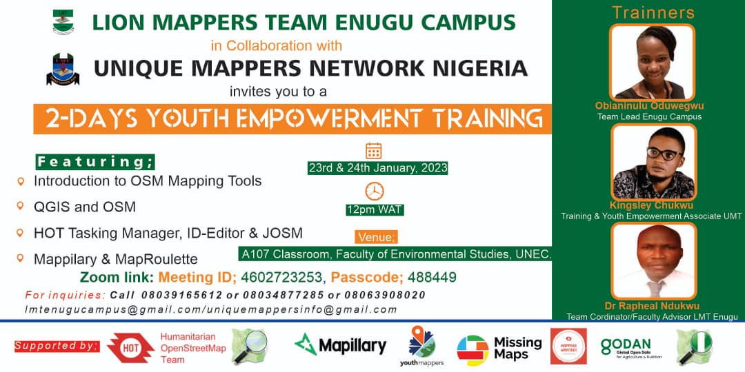
I have been contributing to OpenStreetMap (OSM) since September 2022 under the umbrella of the Uniquemappers network and some of the ways I have contributed are: I have spent over 130 hours mapping on the HOT tasking manager and I have a total of 4,267 buildings, 105 km of roads mapped, and 16 km of waterways mapped, so I have a total of 1613 edits. I have Validated 28 tasks by reviewing and verifying the accuracy of existing data on the map. I Actively participate in my Mapathon center at the University of Nigeria Enugu campus, where I am the team lead and I have trained over 20 mappers. I have a good knowledge of the JOSM and ArcGIS in mapping. I have headed the organizing of mapping Projects where my team participates in mapping projects focused on specific regions, themes, or events.
Posted by Obianinulu on 2 July 2023 in English.
“Never doubt that a small group of thoughtful, committed citizens can change the world; indeed, it’s the only thing that ever has.”
– Margaret Mead
During the 2-days youth empowerment training at the university Nigeria Enugu campus in January 2023, I trained the LionMappers team Enugu campus on how to contribute to HOT manager using the I.D Editor. It is exciting to be a part of a team of young volunteers who actively contribute to society through mapping.
The Land Transport Authority (LTA) Quick Response (QR)-code Parking System was created to tackle indiscriminate parking of shared bicycles. It is mandated and regulated by the Singapore government on bicycle sharing operators.
Since it’s initial rollout, it has been expanded to “device-sharing services”.
QR-code
The QR-codes themselves are static, and take on the form “XXX-YYYY” Where “X” is an acronym of the general area, while “Y” is a hexadecimal value.
| “X” value | Location |
|---|---|
| BIS | ? |
| HOG | Hougang |
| SKG | Sengkang |
Locations
These QR-codes can typically be found under HDB void decks and near bus stops.
Those near bus stops are typically not covered (covered=no) and are either on grass pavers (surface=grass_paver) or cement (surface=cement).
Types of Locations
The parking locations can be broken down in to 2 forms:
-
Existing bicycle parking infrastructure. These are typically
bicycle_parking=two_tierorbicycle_parking=wall_loops. - Standalone. A yellow box with a bicycle logo in the center, and a QR code at the bottom-right corner.
Known Locations
To my knowledge, neither the parking spots nor the associated QR-codes are available for download by the general public. However, locations may be discoverable via the bicycle sharing operators’ apps.
I’ve begun uploading these locations to OpenStreetMap through surveying. Currently focusing around the Hougang/Sengkang area.
Mapping
All bicycle rental dropoff points are marked as a standalone node. Based on some trial-and-error, these are my recommended tags:
Posted by SColchester on 29 June 2023 in English.
HOT Tasking Manager users with projects using Maxar Imagery - what to do next?
Maxar imagery has been down for all Tasking Manager projects for one week now (and for OSM, iD and JOSM in general). If your projects are set to Maxar imagery they are very unlikely to make any progress unless you switch to an alternative imagery source as soon as you get a chance.
This short guide outlines the steps you can take to switch your Tasking Manager project(s) to alternative imagery sources.

The best alternative imagery is completely dependent upon the location of your project(s):

I want to share my experience using the CAD Tools plugin for drawing ways with smooth bends in JOSM. I want to emphasize that I don’t claim that this mapping method is the right or useful one. Most mappers tend to show object contours with as few points as possible. I see the advantages of this approach as it makes data easier to edit, especially in mobile and browser-based OpenStreetMap editors.
On the other hand, smooth line bends work well for the shape of most objects we map. Roads, being one of the main features on maps, are always represented by smooth lines best described by Bézier curves. Coastal lines of various water bodies almost always have smooth bends.
My considerations are as follows: the closer the data represents the true shape of an object, the more accurate the data is. Ultimately, my main motivation is that smooth lines are very aesthetically pleasing.

Continuing last week’s trip from Duluth, MN to Ashland, WI with a loop around Bayfield County.
Now that I’m on the lake shore, I started seeing a bunch of bikes around, even where there isn’t much bike infrastructure.
Ashland, WI
Around 1900, Ashland was the third-largest Great Lakes port after Chicago and Buffalo. In recent years they have reclaimed the waterfront ore dock and brownfields for parks. A paved trail connects beaches to downtown and the Wal-Mart.
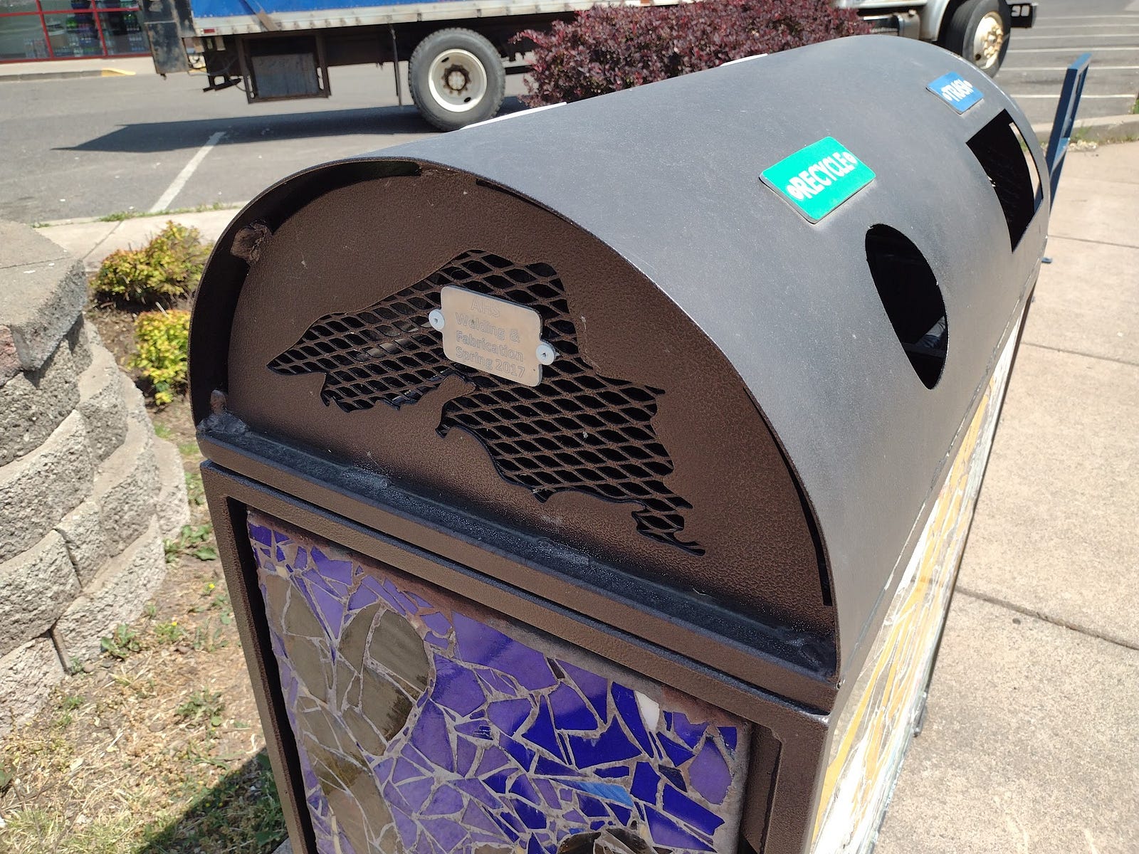
When I arrived in Ashland, I locked the bike at the library. Semi-recently (after the 2015 StreetView), the city got Lake Superior-themed bike racks along Main Street. There could be more of these. The local high school is making these and Lake Superior-themed trash cans.
Posted by wcedmisten on 26 June 2023 in English.
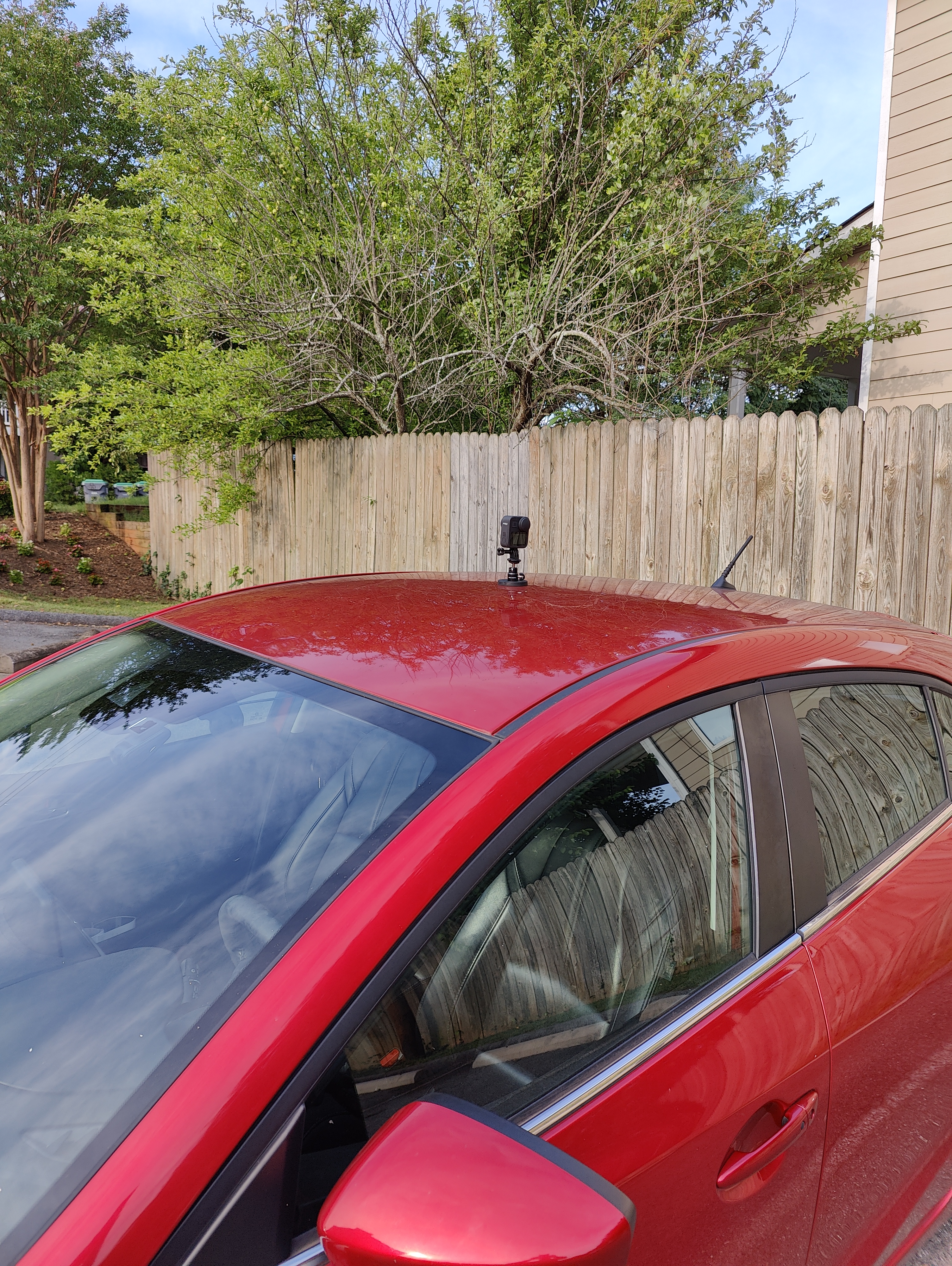
An Impulse Buy
I recently bought a GoPro MAX on sale for $400, with the intent of collecting footage for Mapillary. However, I have yet to get the desktop app working on Ubuntu 22, and haven’t been able to authenticate using their CLI tool, so I haven’t uploaded anything.
Mounting the GoPro on my car
I’m using a magnetic mount to attach the gopro to the roof of my car. I was a bit nervous driving at highway speeds, but so far it’s held up going around 50 mph. The magnet is quite strong and takes some force to remove.
Processing the video locally
As a workaround, I’m just analyzing the footage locally using the mapillary_tools utility to locally process the footage into geotagged images and JOSM to view them.
This has the added advantage of preserving my privacy, since I’m a bit concerned about giving my geotagged video to Meta. This way I only upload a limited amount of data relevant to what I’m surveying.
In the course of working with GNIS data from the US Geological Survey, I’ve sometimes been frustrated with the limited range of expression in OSM tags for natural features. For example, we have a lot of tags that can be applied to a Bench as a place for a people to sit, but nothing specific to identify a Bench as a geographic landform other than tagging the edges as natural=cliff or natural=earth_bank.
There have been some good efforts to improve geological tagging, such as the Proposal for additional volcanic features and the Categories of Sea Areas, which give us broader vocabularies for some features. Strangely, the seamark:sea_area:category=* tag set is more expressive for undersea features than the OSM tags we have for features on land!
So, I decided to put together a Glossary of landforms for OSM, based on a similar glossary on Wikipedia. In the process, I’ve found that OSM does have a broad set of tags for geographic features, although many of them have limited or no documentation.
I also think that there is an opportunity to expand the values of the geological=* tag to include more types of geological features. If the main tag for a features is natural=* or something similar, that can identify the general shape of the landform and be the main tag used by renderers. The addition of a geological=* tag can add more specificity to the feature and identify the nature and structure of the landform. For example, the famous Sugarloaf Mountain in Rio de Janeiro is not just a mountain, but a Bornhardt. So, we might consider adding a geological=bornhardt tag to the feature.
If you have an interest in mapping natural features, check it out:
Glossary of landforms
It’s certainly a work in progress and there are some prospective tags on the list that aren’t currently in use, but I hope it might be useful. If anyone has input, I’d be very happy to have some additional contributions to the effort!


Recently, I applied for the mentorship program and after about 2 weeks of the starting date, I am part of a group that I see as a community of practice to share our common knowledge and improve the OSM Community.
For this program that goes until october 2023, I’m proposing to create a Guideline document to map water areas (amphibious cultures home), water bodies and flood zones as swamps, based on the use case of the Sinú River Low Basin in Córdoba Department, Caribbean region of Colombia.
I hope this Guidelines could help us to improve the mapping task instructions for this area.
Posted by chris_debian on 24 June 2023 in English.
Last updated on 2 September 2024.
I live in Wiltshire (UK), and when out walking, often see public footpaths that have fallen into disuse, and risk being completely overgrown and overlooked by the general public.
Using existing OSM data, I wonder whether lesser used footpaths could be revived; and UK (and beyond?) users encouraged to use paths, for health and wellbeing benefits, and contribution to mapping.
My idea is that this could be gamified. Users of a simple new app, or of functionality added to an existing app, would score points for walking/ wheeling along recognized paths. Different scoring could be used, for example:
*For every 100 yds/ mtrs, or path segment (?), a point could be earned.
*For paths that are used less regularly, i.e., haven’t had a GPS trace for a specified amount of time, could score more points.
*In order to encourage use of the path by a diverse range of users, including wheelchair users, significantly more points could be awarded for these users taking part.
*Points for a successful upload of a recorded GPS track.
The obvious benefits to the OSM community, and users, would be the potential to increase the amount of GPS traces that are uploaded, therefore enabling accuracy checks, and also being able to offer up additional mapping data, perhaps by using apps such as StreetComplete.
An additional benefit in the UK, would be for the Ramblers “Don’t Lose Your Way” project. This initiative is seeking to reclaim footpaths that have for, historical reasons, dropped off the Definitive Map, as Public Rights of Way. As these paths are reclaimed, walkers and wheelers would be encouraged to use the reclaimed routes, in order to earn points; therefore establishing usage and encouraging more people to use the route.
If you have any thoughts around this idea, please comment here.
Many thanks,
Chris.
*** 2 Sep 2024: Update, “MOROW” added to GitHub
Posted by afimaamedufie on 24 June 2023 in English.
Hi everyone,
My name is Afi from Ghana. Last weekend, I attended OSCAFEST 2023, held in Lagos, Nigeria which celebrates and highlight Open Source initiatives, strategies, and tech tools. The event includes a series of talks, workshops, and awareness of open-sourced developer tools.
I was a speaker at the event and I spoke on my mapping experiences, OSM, HOT (Tech Tools such as Tasking Manager) and how OSM promotes the concept of Open Source for Good. I also talked about ways people can contribute to OSM and HOT(tech tools), and join local OSM chapters and I answered a couple of questions.
Link to my slides:
Aside from that, I learned a lot from other talks and joined breakout sessions on topics such as System Failures(SRE), The Power of Storytelling, Writing Documentation That Doesn’t Suck, Coping with Burn Out, Building an Operating system, Open Security, System Design and so much more.
I posted some highlights through tweets which can be found:
It was an amazing experience and I love the fact that I got to share my experiences, talk about HOT(HOT Tech Tools), OSM and collaborated with awesome people across the continent and beyond.

Image Source: Jake Coppinger
Companies like Mapillary and Kartaview have played a significant role in advancing OpenStreetMap (OSM) and enabling detailed mapping efforts, particularly in urban areas. While 360° street-level images have been crucial for capturing high-quality data, there is a growing need for a scalable solution that leverages the power of aerial imagery to further enhance community mapping. In this blog post, we delve into the potential of aerial imaging and its implications for OSM mapping. Interestingly, emerging companies in the 360° imagery space, such as Mapillio (Commercial) and GeoViso (Open Source), may view this as an opportunity to add a unique selling point to their portfolio. The process of generating detailed aerial-like imagery for specific smaller areas not only benefits OSM mapping but also proves highly valuable for city planners involved in intersection redesigns or the addition of bike paths to streets.
I am now going to start working In Franklin Township. Hopefully I can finish at least the Forests, Farmlands, Cities, and possibly some more rural residential areas.
I will start in Chilo, and work my way across the Ohio River. once finished, I will then move along the borders of Franklin Township and I will finish Felicity. After that, I will work on the forests and farms in between Felicity and the borders of the Township.
Chilo will be tackled after I finish the forests and farmlands near it, and this will probably take a couple more edits, not too many though, hopefully.
I want to help edit the map in the Turkish Riviera region. So cities like: Antalya, Izmir, Bodrum and Marmaris will be editted by me. Now im working on the buildings in Marmaris. Greetings, CheetahMapping.

June has always been a hectic month for the LGBT community as several PRIDE celebrations and rainbow-themed collaterals are all over the internet.
For this year, RainbOSM (a safe space for LGBT and allies on OpenStreetMap), MapBeks and the Open Mapping Hub Asia Pacific with HOT thought on casually collaborating in releasing some LGBT tagging information out of the closet (JK!).
This is essentially important as LGBT spaces and features are part of the real world and through OpenStreetMap we are able to digitally make them existent.