This is a place
Diary Entries in English
Recent diary entries
In April, I asked OSM community members to help us out with a better name for the HOT unSummit (which too often was confused with something to do with the United Nations!)
We had more than 100 name suggestions, so thanks a million to everyone who put some thought into it!
The new name for the programme will be…
HOT OpenSummit
So I want to send a big thank you to Courtney Williamson for the suggestion - a token of our appreciation will be on the way soon!
We are working out how to make the actual programme better and will be re-launching it in the coming months. If you know of events (mappy and other) where you think there might be appetite for incorporating open mapping and OpenStreetMap for humanitarian and development purposes, please feel free to reach out (and thanks to those who have already done so!)

Over the weekend we had a great time micro-mapping Hyde Park in Northbridge, and made some new friends! Some attendees of the recent Geogeeks/QGIS Users’ Group presentation evening joined our mapping adventures for the first time.
It was really an amazing and excitting experince today at Uniport Mapathon Center, Uniport Mall Abuja Campus, University of Port Harcourt. As i and team contributted to the ENUGU STATE -MAP NIGERIA MAPATHON CAMPAIGN -LET’S MAP NSUKKA LGA FOR SDGS AND SOCIAL GOOD project.
As the new Team Lead of the center, i was so excitted and greatly encouraged by the enthusiasm and Inpiring interest shown by the team members present, who were majorly newly recruited volunteers. their passion for volunteering and Geospatial data triggered a feeling in my heart.
.
San Jose Diary
According https://www.thedrive.com/the-war-zone/25728/chinas-new-york-city-sized-earthquake-warning-system-sounds-more-like-way-to-talk-to-subs there is a huge secret ELF-antenna in China called WEM. The exact location is so far unknown, but by the fact, that it looks like an overhead powerline which forms according https://www.newsweek.com/china-giant-antenna-navy-submarine-new-york-city-secret-location-1276332 a cross shape, so it will be able to be mapped by satellite pictures.
Last weekend, I had the opportunity to accompany a friend to an archaeological survey on Ballygawley Lough in Co. Sligo. He’s a metal detectorists who detects on archaeological sites - with a license. Metal detecting is highly restricted in Ireland. There were three divers - one of them had worked on Banshees of Inisheer and Vikings! (At least two of them do diving for movies regularly.) One of the divers doubled as metal detectorist as well, but he also had a sonar device on his canoe. When I had a peak at the screen, I discovered that it was using OpenStreetMap! With attribution! It’s the Lowrance Elite ti2, if anyone is interested. I can’t find any mention of OSM on their website.
There are two crannógs on the lake which was part of why I went with them. I had never seen one in real life, mapped a lot and discovered a few, but never actually seen one. I was offered the spare canoe, but I chickened out when it came to actually paddling over there.

Posted by rupertmaesglas on 9 May 2023 in English.
I’ve been invited to go to Jordan to consult on a new OSM project involving Jordan’s Royal Scientific Society, the local Youthmappers chapter in Amman, and the Princess Sumaya University, coordinated/commissioned by the UNESCO research chair, Science Communicator Iain Stewart.
The location is Asraq (think Lawrence of Arabia, and ancient Petra; the area sometimes called the ‘Cradle of Civilisation’. Over the centuries, the area has been settled and travelled by many people - from silk-road traders to Moses’s biblical journey, incoming 11th century Druze, to modern syrian refugees.
The wetlands have different cultural significance and inspire/necessitate different cultural practices for many ethnicities, and the now desert has gone through climatic and human-influenced changes which exemplify one of Jordan - and the planet’s - biggest challenges: water supply.
As with so many Disaster Risk environemnts, the problem is compound in nature: climate change has turned once fertile wetlands into desert, whilst Jordan’s excellent record of refugee hosting has meant massive population growth. Result: decreased supply and increased demand for water supply.
I’m looking forward to working with diverse local voices to understand how OpenStreetMap might present some solutions, and am expecting a fascinating mix attitude, behaviour and shared-interest around Water Resource mapping and with Community Asset mapping.
I just realized that a water well is sometimes privat and sometimes not even visible to people. I feel so sorry that I commited removal requests of some water wells in Portugal because I could not find drinking water there…. from now on I only search for “drinking water” or “spring” on osm.

Sharing from my post on https://blog.georeactor.com
Belgium’s Baarle-Hertog and the Dutch Baarle-Nassau overlap in one town riddled with border crossings and enclaves. Let’s take a look at OpenStreetMap:
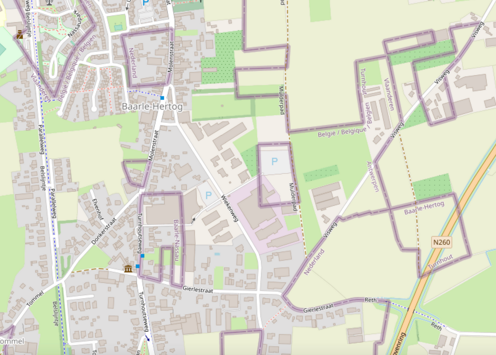
Wow, it looks complicated!
Legend depicts Baarle as a Kafkaesque theme park where buildings swap countries and laws are fluid. Sample anecdote:
There was a time when according to Dutch laws restaurants had to close earlier. For some restaurants on the border it meant that the clients simply had to change their tables to the Belgian side.
I likely learned about this town from the Google Sightseeing Blog a long time ago. As a maps nerd, I knew that I had to see it for myself one day.
Getting there
In April 2023, I took a train from Brussels to Antwerp, checked out the award-winning Port Authority Building, then another train onward to Turnhout, then a bus to Baarle-Hertog.

amenity=hitching_post
Short and easy, 214 uses.
tourism=trail_riding_rest
Well, it may contain one or more hitching posts. 1 use. That’ll be the person who wrote it up for the wiki and linked it about for good visibility. Ooh, and it’s rendered on the trail riding map. Perhaps it was made because other resting places are possible, so this becomes a unifying tag to look for if you are looking for a place to rest your horse? Much like a tourism=trail_riding_station seems to be a unifying tag to put on all the different things you can overnight your horse in? (1339 uses for that one, it’s doing a better job. Oh, except that I looked at how it was actually being used and some of it was for staging locations where overnighting would be illegal. So not all correct uses. And I can definitely see where the confusion comes from.) Although if these things are meant to be a unifying device, used in addition to the more specific tags, it probably ought to say that on the wiki page. Is that even how tags are meant to be used? I certainly see the utility.
amenity=animal_hitch
animal_hitch=ring/rail/post
horse=yes
er…
mule=yes
donkey=yes
llama=yes
Perhaps you should just be assuming your zebra/donkey cross or whatever other exotic bit of stock you’ve got =yes? Except if you’re in big horn sheep country, it very well might be that goat=no.
104 uses for all animals, but it isn’t popular enough to get combination details. For the type tag, there are 83 rings and 7 rails, but no posts at all. Nope, the people don’t want it for hitching posts. Well, except for the sorts who get particular about the post being horizontal between two other posts, AKA a rail. Or particular about there being a ring on the post, but the example dog_hitch (not kidding) is also a ring.
Oh, there’s also 2 uses of amenity=horse_hitch.

- Rivers and lakes may move 10 meters in 5 years.
- When you map a river, treat it like low-poly art.
- Think of the next mapper 3 years from now. No 200 point rivers. No holding space bar.
Simple rivers enable simple change.
Opening June 29th over 2 km between existing roads Vejledalen and Mælkevejen in the town Vejle, Denmark - Please Update! :-)
Hi, everyone,
Between the end of April and mid-May, my former TomTom colleagues * and I posted a communications survey with the goal of gathering some information about how OSM users experience OSM community communications. Now that the survey is complete, I want to give it context as part of our presentation at State of the Map US in Richmond, Virginia.
At SotM US, we will be presenting on How to Use Data for Effective Community Communication. (The project is supported by TomTom and informed by work that two of us have done for the CWG, but it’s not formally a TomTom or OSMF project.) Our primary source of data for this presentation is derived from a tool that scrapes publicly available, anonymized, channel data from OSM listservs and forums. To augment this data, we created a communications survey. We knew that we would not be able to get a broadly representative cross-section of the OSM user demographic with our limited time and resources, but we did believe we would get some additional details that could help inform our approach.
The survey had a mix of free answer and multiple choice questions about demographics, local community involvement, and experiences using the various forums, lists and other channels. We created 12 versions of the same survey to post in 12 different channel types so that we could get a sense of the user demographics per channel: community forum, mailing list, Telegram, Twitter, Discord, Slack, Mastodon, Reddit, IRC/Matrix, weekly OSM, Facebook, LinkedIn. We received 464 responses, with more responses from Europe and North America than from Latin America, Asia and Africa. We will present a few of the observable trends at our presentation, with the caveat that they are more impressionistic than representative.
Sanawad city boundry for Wikipedia by akmal khan
Posted by Peter Elderson on 30 April 2023 in English.
Last updated on 13 May 2023.
Turbo roundabouts are relatively new. They first appeared in Nederland, but are now starting to appear in many countries, including the US. I have tried my hand at mapping one, guided by a few front runners, then did a second one on my own. This diary entry details what I learned. As I go on, I will add things learned to this diary entry!
See [roundabout=turbo] (osm.wiki/Tag:roundabout%3Dturbo)
Variations: It’s hard to find two turbo roundabouts that are exactly the same. This is what I learned: Take care to start with an easy one, and never blindly apply the prescriptions. You have to know what it’s for. That’s why this diary entry contains a lot of explanation: those are the things I learned from the experts! Too bad the three-lane rotor roundabout in Rosmalen has already been mapped.
Mapping a turbo roundabout with JOSM
Tools used
JOSM with a detailed aerial photo background layer and style Lane and Road attributes active. This job would be near impossible with Id.
Skills required
Basic OSM editing: drawing and tagging nodes, ways, areas and relations. Cutting ways (P). Link ways to existing nodes and ways (Esc-drop, M, N). Unkink ways. Extend ways. Combining ways (C). Reverse ways (R). Copy and paste elements (Control-C and Control-V).
Skilled editing: Adjusting lines with O (round) and Q (straight). Create turn restriction relations: tag, add elements and assign roles to, via from. Use existing turn restriction to duplicate and adapt for a new restriction. Route relations: download members, identify ordering problems and membership problems, and correct sorting errors.
What?
Anton Khorev’s post inspired me to see what would happen if I open the iD Editor in landscape instead of portrait.
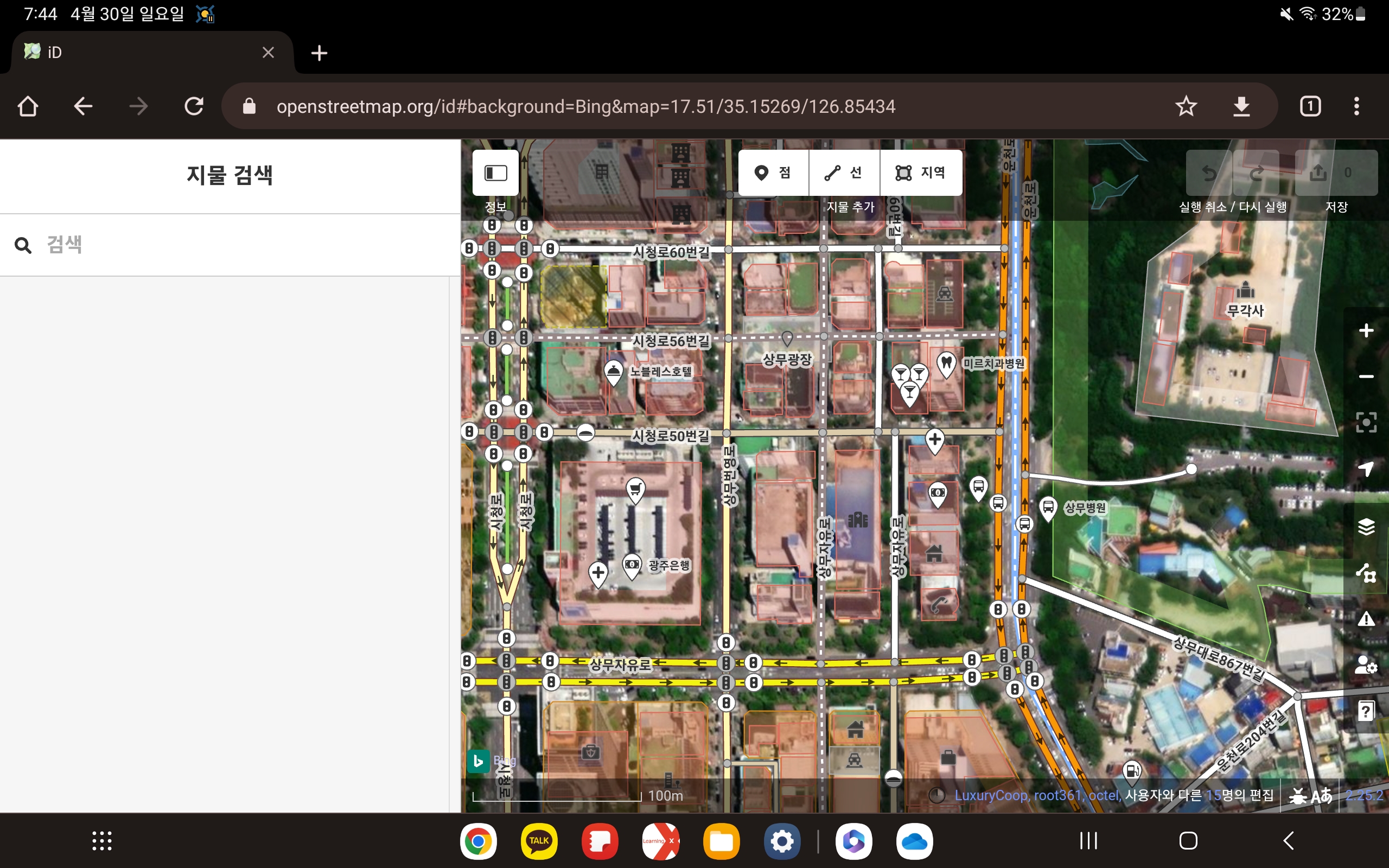
I’ve opened the iD editor in Google Chrome on my Galaxy Tab S7. it’s editable enough as it is, it would be nice to be able to turn it full screen.
Posted by JaneAmerica12 on 29 April 2023 in English.
It was awesome and amazing
Today was a great day. I learnt how to map out a location and I contributed by mapping out some buildings and some pathways. I know I’m a a beginner in this but I find it surprisingly fun and interesting. I mapped out Abi Local government area and I’m happy.
Posted by Starman6059 on 29 April 2023 in English.
Contributed in mapping buildings and roads.